Map of Canterbury,16th century
Bildnummer 11727760
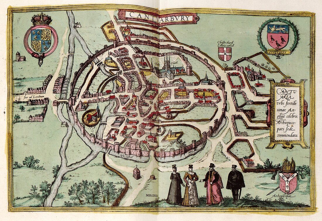
| Map of Canterbury. 16th-century map of the cathedral city of Canterbury during the Tudor period. In the top corners are Tudor (left) and City (right) coats-of-arms. Canterbury Cathedral (founded 597) is at upper centre. The circular city walls and castle (lower centre) and the Great Stour river (left) are also shown. The archbishop's coat-of-arms is at bottom right,with a Latin inscription at centre right. The vignette (lower centre) shows local dress. This is a 1612 edition of a map first published in volume 4 (1588) of the city atlas 'Civitates orbis terrarum'. This atlas was edited by Georg Braun (c.1540-1622) and largely engraved by Franz Hogenberg | |
| Lizenzart: | Lizenzpflichtig |
| Credit: | Science Photo Library / LIBRARY OF CONGRESS, Geography and Map Division |
| Bildgröße: | 5310 px × 3650 px |
| Modell-Rechte: | nicht erforderlich |
| Eigentums-Rechte: | nicht erforderlich |
| Restrictions: | - |
Preise für dieses Bild ab 15 €
Universitäten & Organisationen
(Informationsmaterial Digital, Informationsmaterial Print, Lehrmaterial Digital etc.)
ab 15 €
Redaktionell
(Bücher, Bücher: Sach- und Fachliteratur, Digitale Medien (redaktionell) etc.)
ab 30 €
Werbung
(Anzeigen, Aussenwerbung, Digitale Medien, Fernsehwerbung, Karten, Werbemittel, Zeitschriften etc.)
ab 55 €
Handelsprodukte
(bedruckte Textilie, Kalender, Postkarte, Grußkarte, Verpackung etc.)
ab 75 €
Pauschalpreise
Rechtepakete für die unbeschränkte Bildnutzung in Print oder Online
ab 495 €
Keywords
- 1500er Jahre,
- 16. Jahrhundert,
- beschriftet,
- Canterbury,
- Civitates Orbis Terrarum,
- Dom,
- Ehefrau,
- England,
- Englisch,
- Erwachsene,
- Etikette,
- Etiketten,
- Europa,
- europäisch,
- Fluss,
- Franz Hogenberg,
- Frau,
- Gebäude,
- geografisch,
- Geographie,
- Georg Braun,
- Geschichte,
- Händler,
- historisch,
- Illustration,
- Karte,
- Kartographie,
- kaukasisch,
- Kirche,
- Kirchen,
- Kunstwerk,
- Latein,
- Mann,
- Männlich,
- Mensch,
- Menschen,
- menschliche Geografie,
- Mittelalterlich,
- mittleren Alters,
- Niemand,
- Person,
- Schloss,
- Stadt,
- städtisch,
- Text,
- Tudor,
- Tudorzeit,
- Weiblich,
- weiß