Nishinoshima volcanic eruption,2013-14
Bildnummer 11678889
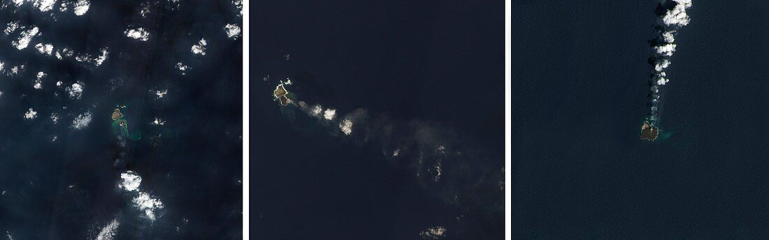
| Nishinoshima volcanic eruption,2013-14. Montage of three satellite images (North at top) showing the Pacific volcanic island of Nishinoshima,south-east of Japan,growing in the period 2013 to 2014. Prior to eruptions in 1973-74,this island was the peak of an underwater volcano that had not erupted for over 10,000 years. The eruption that started in November 2013 created a new island to the south-east,shown at left (8 December 2013). At centre (24 December 2013) the two islands are beginning to merge. By 30 March 2014 (right) the islands have fully merged and grown to around a kilometre across (the original island was around 500 metres across) | |
| Lizenzart: | Lizenzpflichtig |
| Credit: | Science Photo Library / NASA Earth Observatory |
| Bildgröße: | 6291 px × 1969 px |
| Modell-Rechte: | nicht erforderlich |
| Eigentums-Rechte: | nicht erforderlich |
| Restrictions: | - |
Preise für dieses Bild ab 15 €
Universitäten & Organisationen
(Informationsmaterial Digital, Informationsmaterial Print, Lehrmaterial Digital etc.)
ab 15 €
Redaktionell
(Bücher, Bücher: Sach- und Fachliteratur, Digitale Medien (redaktionell) etc.)
ab 30 €
Werbung
(Anzeigen, Aussenwerbung, Digitale Medien, Fernsehwerbung, Karten, Werbemittel, Zeitschriften etc.)
ab 55 €
Handelsprodukte
(bedruckte Textilie, Kalender, Postkarte, Grußkarte, Verpackung etc.)
ab 75 €
Pauschalpreise
Rechtepakete für die unbeschränkte Bildnutzung in Print oder Online
ab 495 €
Keywords
- 2013,
- 2014,
- 21. Jahrhundert,
- 3,
- Asche,
- Bildung,
- Drei,
- eo-1,
- Erdkunde,
- Feuerring,
- Formation,
- Geologie,
- geologisch,
- Gipfel,
- Insel,
- Japanisch,
- Meer,
- Montage,
- NASA,
- Neu,
- neues Land,
- Niemand,
- Oberfläche,
- Ozeanien,
- Pazifik,
- Plume,
- Reihenfolge,
- Satellit,
- Satellitenbild,
- Serie,
- Trio,
- Unterwasservulkan,
- Vulkan,
- vulkanisch,
- Vulkanologie,
- Wachsen,
- wachsend,
- Weltall,
- Wolken