Layered south polar deposites,Mars
Bildnummer 11672549
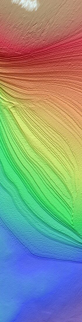
| Layered south polar deposits,Mars,coloured digital terrain model (DTM). DTM data,also known as a digital elevation model,offers 3-D representation of a terrain's surface. The map is coloured according to height from the lowest to highest: dark blue,green,yellow,red and white. Seasonal melting and reformation of ice and dust create layers on both northern and southern polar regions. The data here was acquired by the High Resolution Imaging Science Experiment (HiRISE) camera on NASA's Mars Reconnaissance Orbiter (MRO) | |
| Lizenzart: | Lizenzpflichtig |
| Credit: | Science Photo Library / NASA |
| Bildgröße: | 949 px × 3720 px |
| Modell-Rechte: | nicht erforderlich |
| Eigentums-Rechte: | nicht erforderlich |
| Restrictions: | - |
Preise für dieses Bild ab 15 €
Universitäten & Organisationen
(Informationsmaterial Digital, Informationsmaterial Print, Lehrmaterial Digital etc.)
ab 15 €
Redaktionell
(Bücher, Bücher: Sach- und Fachliteratur, Digitale Medien (redaktionell) etc.)
ab 30 €
Werbung
(Anzeigen, Aussenwerbung, Digitale Medien, Fernsehwerbung, Karten, Werbemittel, Zeitschriften etc.)
ab 55 €
Handelsprodukte
(bedruckte Textilie, Kalender, Postkarte, Grußkarte, Verpackung etc.)
ab 75 €
Pauschalpreise
Rechtepakete für die unbeschränkte Bildnutzung in Print oder Online
ab 495 €
Keywords
- 1,
- 21. Jahrhundert,
- 3-d,
- 3D,
- Digitales Geländemodell,
- digitales Höhenmodell,
- dtm,
- Einlagen,
- Eis,
- farbig,
- gefärbt,
- Gefroren,
- geografisch,
- Geographie,
- Geologie,
- geologisch,
- Geschichtet,
- HiRISE,
- hochauflösende Bildgebung,
- Höhe,
- Karte,
- Linderung,
- Mars,
- MRO,
- NASA,
- Oberfläche,
- Planet,
- polar,
- Raum,
- Satellit,
- Satellitenbild,
- Sonnensystem,
- Süd-,
- Südpol,
- Terrain,
- topografisch,
- Topographie,
- topographisch,
- Weltraumflug