The Alps,3D artwork
Bildnummer 11646444
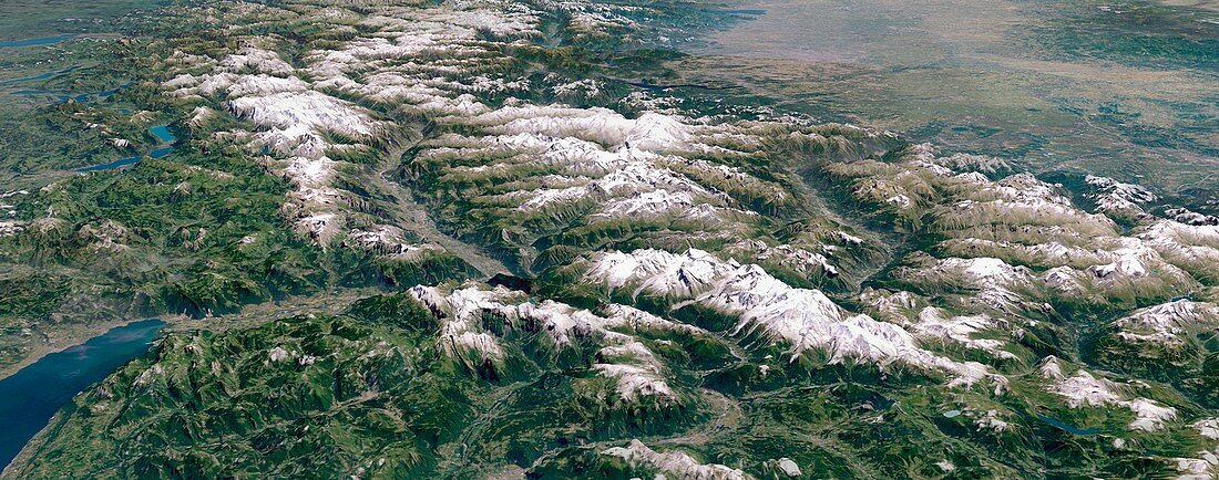
| The Alps. Simulated 3D high-altitude panoramic view of the Alps,viewed from the west. Image based on Landsat satellite images and detailed digital terrain data. Prominent physical features include the Mont Blanc Massif and the Chamonix Valley (foreground centre),Lake Geneva (foreground left),the broad valley of the Rhone river (centre),with the Pennine Alps and the Aosta Valley to the south (right) and the Bernese Alps and Swiss lakes to the north (left). Individual peaks may be discerned,including Mt Blanc,the Matterhorn and the Eiger. In the distance lie Lake Maggiore,Milan and Italy's Po Basin (top right),and Lake Constance on the Swiss/German border (top left) | |
| Lizenzart: | Lizenzpflichtig |
| Credit: | Science Photo Library / Planetary Visions |
| Bildgröße: | 6686 px × 2637 px |
| Modell-Rechte: | nicht erforderlich |
| Restrictions: | - |
Preise für dieses Bild ab 15 €
Universitäten & Organisationen
(Informationsmaterial Digital, Informationsmaterial Print, Lehrmaterial Digital etc.)
ab 15 €
Redaktionell
(Bücher, Bücher: Sach- und Fachliteratur, Digitale Medien (redaktionell) etc.)
ab 30 €
Werbung
(Anzeigen, Aussenwerbung, Digitale Medien, Fernsehwerbung, Karten, Werbemittel, Zeitschriften etc.)
ab 55 €
Handelsprodukte
(bedruckte Textilie, Kalender, Postkarte, Grußkarte, Verpackung etc.)
ab 75 €
Pauschalpreise
Rechtepakete für die unbeschränkte Bildnutzung in Print oder Online
ab 495 €
Keywords
- 3-dimensional,
- 3D,
- Alpen,
- alpin,
- Aostatal,
- Berg,
- Berge,
- bergig,
- Berner Alpen,
- Bodensee,
- Deutsche,
- Deutschland,
- Dreidimensional,
- Eiger,
- Europa,
- europäisch,
- Frankreich,
- Französisch,
- gebirgig,
- Genfer See,
- geografisch,
- Geographie,
- Geologie,
- geologisch,
- Gipfel,
- Italien,
- Italienisch,
- Kunstwerk,
- Landschaft,
- Luftaufnahme,
- Mailand,
- Modell-,
- Panorama,
- Panorama-,
- Reichweite,
- Rhone,
- Satellit,
- Satellitenbild,
- Schneebedeckt,
- Schweiz,
- Seen,
- Simulation,
- simuliert,
- Täler,
- Terrain,
- Umwelt,
- Weltall