Earthquake tension maps,Turkey
Bildnummer 11638623
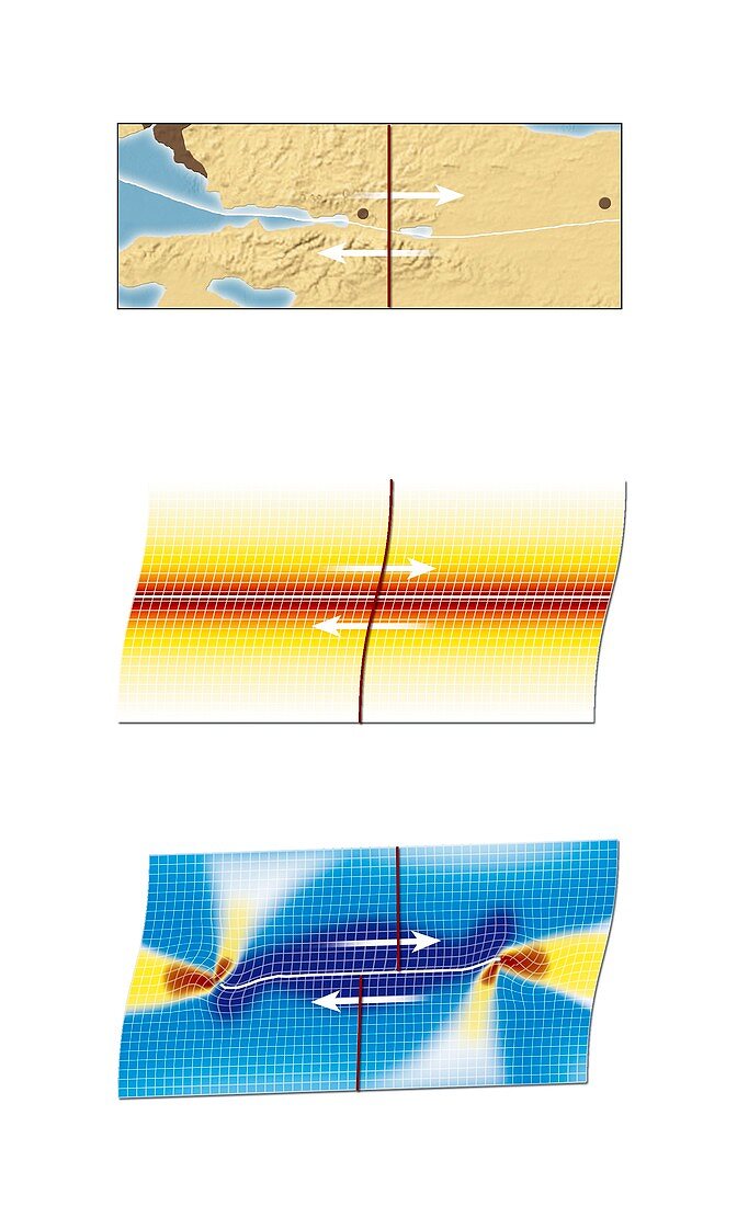
| Earthquake tension maps,north-western Turkey. At top is the area around the city of Izmit (brown dot,centre). Part of Istanbul is at upper left,and the city of Ducze is at far right. The white line shows the subduction zone (North Anatolian Fault) where the Eurasian Plate and the Anatolian Plate meet. White arrows show movement during the earthquake. The second diagram (middle) shows the tension along the fault before the earthquake. The third diagram (bottom) shows how the tension shifted to two areas (red and yellow) where further earthquakes are expected. A large 7.6-magnitude earthquake struck Izmit on 17 August 1999 | |
| Lizenzart: | Lizenzpflichtig |
| Credit: | Science Photo Library / Lunau, Claus |
| Bildgröße: | 2562 px × 4193 px |
| Modell-Rechte: | nicht erforderlich |
| Eigentums-Rechte: | nicht erforderlich |
| Restrictions: | - |
Preise für dieses Bild ab 15 €
Universitäten & Organisationen
(Informationsmaterial Digital, Informationsmaterial Print, Lehrmaterial Digital etc.)
ab 15 €
Redaktionell
(Bücher, Bücher: Sach- und Fachliteratur, Digitale Medien (redaktionell) etc.)
ab 30 €
Werbung
(Anzeigen, Aussenwerbung, Digitale Medien, Fernsehwerbung, Karten, Werbemittel, Zeitschriften etc.)
ab 55 €
Handelsprodukte
(bedruckte Textilie, Kalender, Postkarte, Grußkarte, Verpackung etc.)
ab 75 €
Pauschalpreise
Rechtepakete für die unbeschränkte Bildnutzung in Print oder Online
ab 495 €
Keywords
- 1900er Jahre,
- 20. Jahrhundert,
- Asien,
- ausgeschnitten,
- Ausschnitte,
- Bewegung,
- Diagramm,
- Erdbeben,
- Erdkunde,
- farbcodiert,
- Farben,
- Forschung,
- Geologie,
- geologisch,
- Geowissenschaften,
- Illustration,
- Karte,
- Karten,
- Kunstwerk,
- Naturkatastrophe,
- Seismologie,
- Tension,
- Truthahn,
- Türkisch,
- Veränderung,
- vorher,
- weißer Hintergrund