1889 solar eclipse chart,USA
Bildnummer 11637113
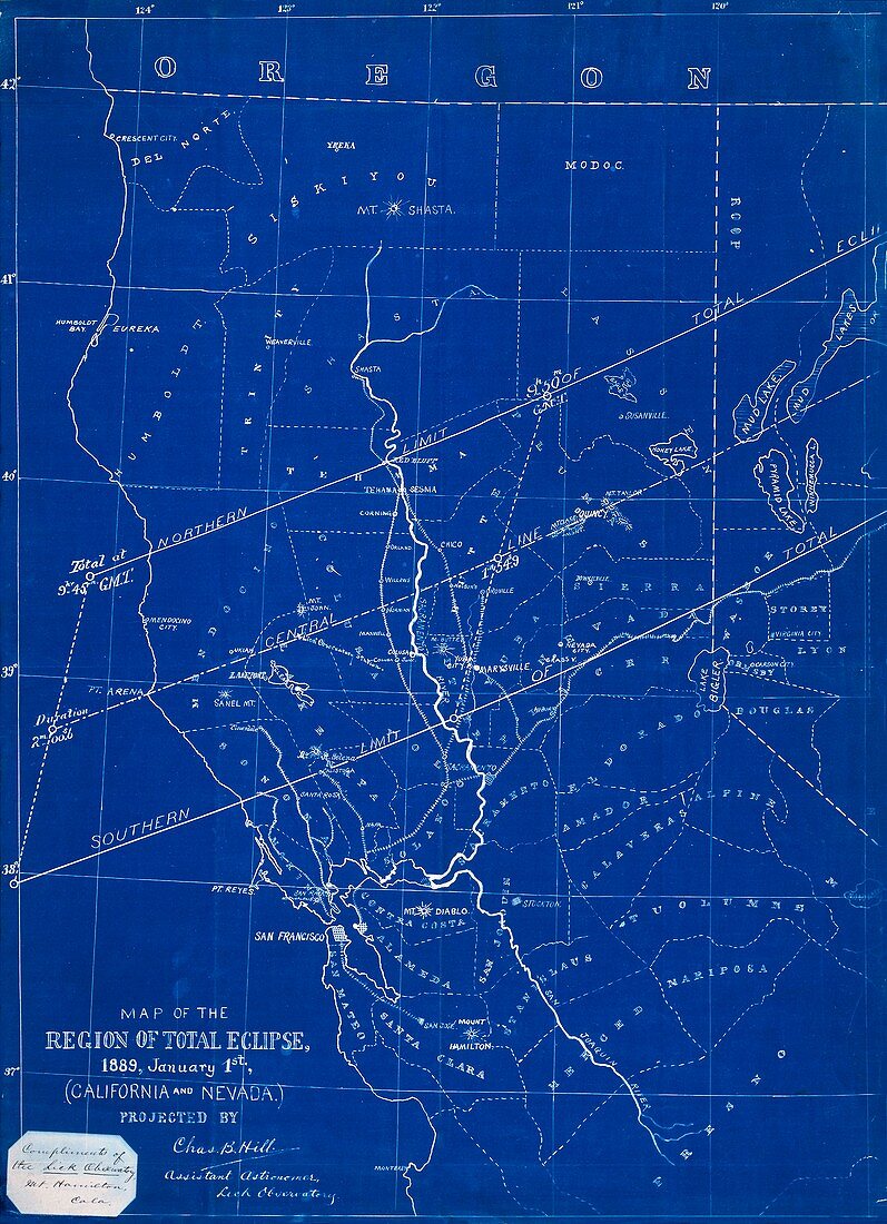
| 1889 solar eclipse chart,USA. Blueprint of the total solar eclipse track over California and Nevada,USA,on 1 January 1889. This chart was prepared by US astronomer Charles B. Hill,an assistant at the Lick Observatory,Mount Hamilton,California,USA. Lines of longitude and latitude are shown,with the track (centre) passing across northern California and into Nevada. The central line is shown,along with northern and southern limits for observation of totality,and the time (UTC) and duration of totality on the centre line. The path of totality passed across the northern Pacific,the western USA,and into central Canada | |
| Lizenzart: | Lizenzpflichtig |
| Credit: | Science Photo Library / Royal Astronomical Society |
| Bildgröße: | 3562 px × 4919 px |
| Modell-Rechte: | nicht erforderlich |
| Eigentums-Rechte: | nicht erforderlich |
| Restrictions: | - |
Preise für dieses Bild ab 15 €
Universitäten & Organisationen
(Informationsmaterial Digital, Informationsmaterial Print, Lehrmaterial Digital etc.)
ab 15 €
Redaktionell
(Bücher, Bücher: Sach- und Fachliteratur, Digitale Medien (redaktionell) etc.)
ab 30 €
Werbung
(Anzeigen, Aussenwerbung, Digitale Medien, Fernsehwerbung, Karten, Werbemittel, Zeitschriften etc.)
ab 55 €
Handelsprodukte
(bedruckte Textilie, Kalender, Postkarte, Grußkarte, Verpackung etc.)
ab 75 €
Pauschalpreise
Rechtepakete für die unbeschränkte Bildnutzung in Print oder Online
ab 495 €
Keywords
- 1800er Jahre,
- 19. Jahrhundert,
- Amerikanisch,
- Astronomie,
- astronomisch,
- beschriftet,
- Diagramm,
- Einfarbig,
- Etikette,
- Etiketten,
- Forschung,
- geografisch,
- Geographie,
- Geschichte,
- historisch,
- Illustration,
- Kalifornien,
- Kalifornisch,
- Karte,
- Kartographie,
- Kunstwerk,
- Nordamerika,
- nordamerikanisch,
- Oregon,
- Ort,
- Prognose,
- Projektion,
- projiziert,
- Region,
- Sonnenfinsternis,
- Spur,
- Süd-,
- uns,
- USA,
- Vereinigte Staaten,
- Zeit