Wales,United Kingdom,satellite image
Bildnummer 11633763
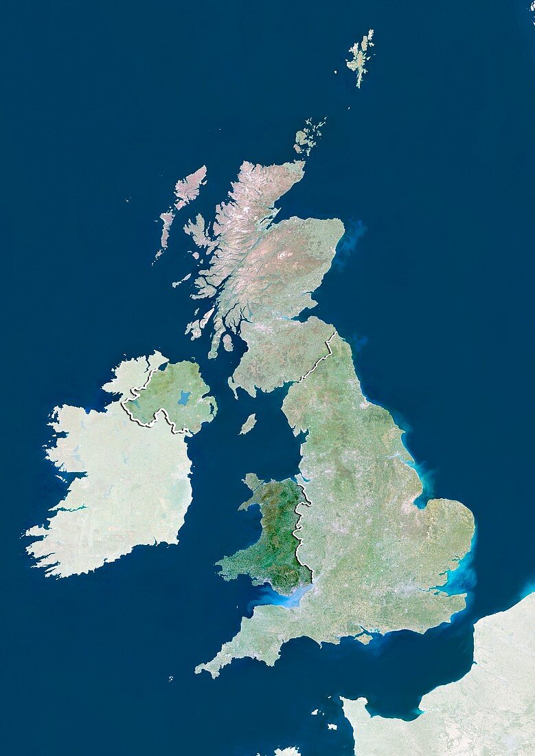
| Wales,satellite image. North is at top. Natural colour satellite image showing Wales in the United Kingdom,with the surrounding territories shaded out. The UK consists of the island of Great Britain (centre) and Northern Ireland - the north-eastern part of the island of Ireland (centre left). Together these islands constitute the British Isles. Great Britain itself consists of Scotland (upper centre),England (centre right),and Wales (centre left). England is separated from France (lower right) by the English Channel (blue,lower right). The Atlantic Ocean (blue,left),Irish Sea (blue,centre),North Sea (blue,right) and Celtic Sea (blue,bottom left) surround the British Isles. Image compiled from data acquired by the LANDSAT 5 and 7 satellites,in. Images highlighting all other regions of this country are available. For further information please contact SPL. Images highlighting all other regions of this country are available. For further information please contact SPL | |
| Lizenzart: | Lizenzpflichtig |
| Credit: | Science Photo Library / Planetobserver |
| Bildgröße: | 3519 px × 4972 px |
| Modell-Rechte: | nicht erforderlich |
| Restrictions: | - |
Preise für dieses Bild ab 15 €
Universitäten & Organisationen
(Informationsmaterial Digital, Informationsmaterial Print, Lehrmaterial Digital etc.)
ab 15 €
Redaktionell
(Bücher, Bücher: Sach- und Fachliteratur, Digitale Medien (redaktionell) etc.)
ab 30 €
Werbung
(Anzeigen, Aussenwerbung, Digitale Medien, Fernsehwerbung, Karten, Werbemittel, Zeitschriften etc.)
ab 55 €
Handelsprodukte
(bedruckte Textilie, Kalender, Postkarte, Grußkarte, Verpackung etc.)
ab 75 €
Pauschalpreise
Rechtepakete für die unbeschränkte Bildnutzung in Print oder Online
ab 495 €
Keywords
- 2000,
- 21. Jahrhundert,
- Atlantischer Ozean,
- Britische Inseln,
- England,
- Erdbeobachtung,
- Europa,
- europäisch,
- Frankreich,
- geografisch,
- Geographie,
- Grenze,
- Grenzen,
- Großbritannien,
- Insel,
- Inseln,
- Irische See,
- Irland,
- Karte,
- Kartographie,
- Keltische See,
- Küste,
- Küsten-,
- Küstenlinie,
- Land,
- Länder,
- Landsat 7,
- maskiert,
- Nation,
- Natur,
- Natürliche Farbe,
- Nordirland,
- Rand,
- Satellit,
- Satellitenbild,
- Schottland,
- Staat,
- topografisch,
- Topographie,
- Ufer,
- Umwelt,
- Vereinigtes Königreich,
- Vogelperspektive,
- Von Oben,
- Wales,
- Weltall