Italy,satellite image
Bildnummer 11633744
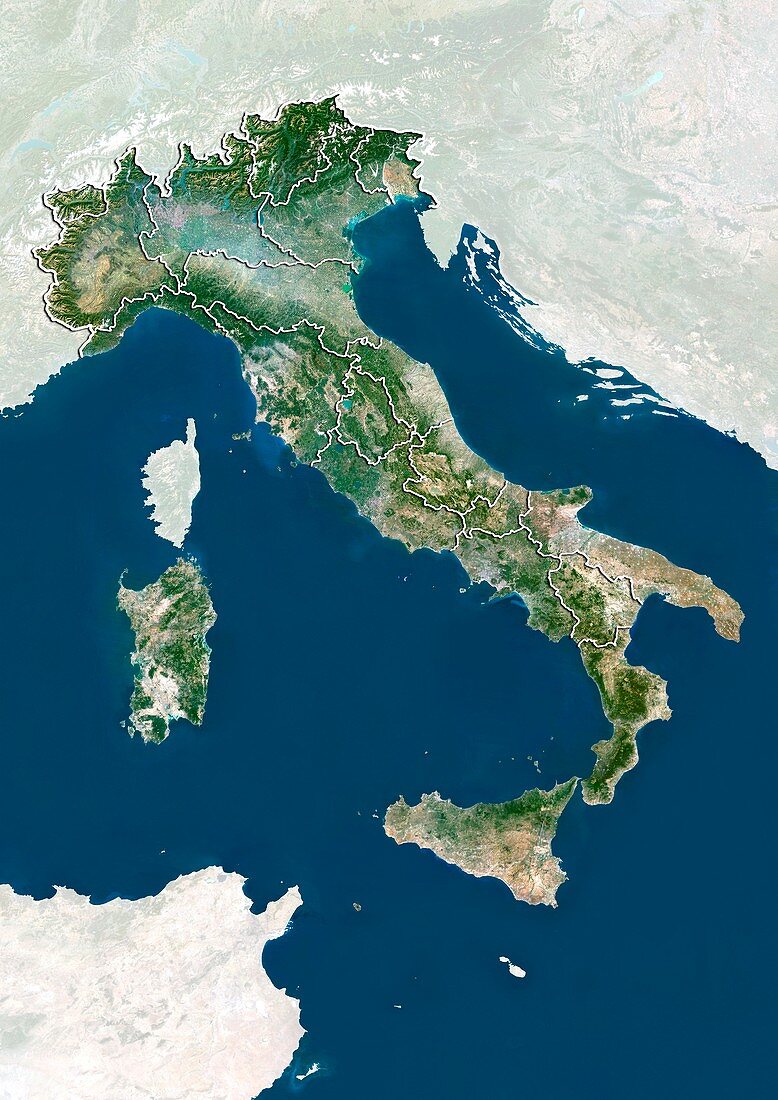
| Italy,satellite image. North is at top. Natural colour satellite image showing Italy divided into its 20 regions. Italy is located in south-central Europe and is bordered by France (upper left),Switzerland (top left),Austria (top centre),and Slovenia (upper right). The Adriatic Sea (blue,upper right),Ionian Sea (blue,right),Ligurian Sea (blue,upper left) and Tyrrhenian Sea (blue,centre) surround the Italian peninsula. To the south of the Italian Peninsula are the islands of Sicily (lower right) and Sardinia (centre left) - the two largest islands in the Mediterranean Sea (blue,lower left to lower right). Image compiled from data acquired by the LANDSAT 5 and 7 satellites,in 2000 | |
| Lizenzart: | Lizenzpflichtig |
| Credit: | Science Photo Library / Planetobserver |
| Bildgröße: | 3527 px × 4984 px |
| Modell-Rechte: | nicht erforderlich |
| Restrictions: | - |
Preise für dieses Bild ab 15 €
Universitäten & Organisationen
(Informationsmaterial Digital, Informationsmaterial Print, Lehrmaterial Digital etc.)
ab 15 €
Redaktionell
(Bücher, Bücher: Sach- und Fachliteratur, Digitale Medien (redaktionell) etc.)
ab 30 €
Werbung
(Anzeigen, Aussenwerbung, Digitale Medien, Fernsehwerbung, Karten, Werbemittel, Zeitschriften etc.)
ab 55 €
Handelsprodukte
(bedruckte Textilie, Kalender, Postkarte, Grußkarte, Verpackung etc.)
ab 75 €
Pauschalpreise
Rechtepakete für die unbeschränkte Bildnutzung in Print oder Online
ab 495 €
Keywords
- 2000,
- 21. Jahrhundert,
- Alpen,
- alpin,
- Berg,
- Berge,
- Erdbeobachtung,
- Europa,
- europäisch,
- Frankreich,
- geografisch,
- Geographie,
- Grenze,
- Grenzen,
- Insel,
- Inseln,
- Italien,
- Karte,
- Kartographie,
- Küste,
- Küsten-,
- Küstenlinie,
- Land,
- Länder,
- Landsat 7,
- ligurisch,
- maskiert,
- Mittelmeer,
- Nation,
- Natur,
- Natürliche Farbe,
- Österreich,
- Rand,
- Region,
- Sardinien,
- Satellit,
- Satellitenbild,
- Schweiz,
- Sizilien,
- Staat,
- topografisch,
- Topographie,
- Tyrrhenisches Meer,
- Ufer,
- Umwelt,
- Vogelperspektive,
- Von Oben,
- Weltall,
- wolkenlos