Belgium,satellite image
Bildnummer 11633730
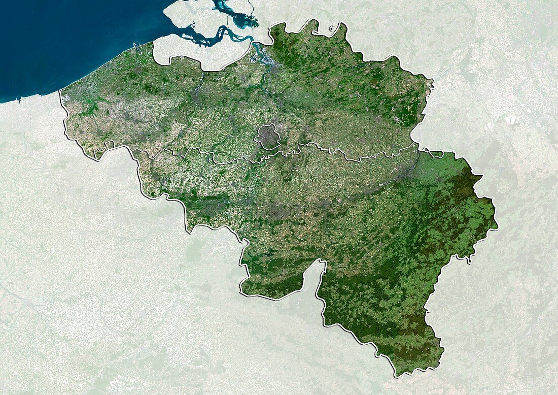
| Belgium,satellite image. North is at top. Natural colour satellite image of Belgium,divided into its three regions: Walloon Region (Wallonia,bottom),Flemish Region (Flanders,top),and Brussels-Captial Region (Brussels,small,centre). Belgium is bordered by France (lower left),Germany (right),Luxembourg (lower right),the Netherlands (Holland,top),and the North Sea (blue). Image compiled from data acquired by the LANDSAT 5 and 7 satellites,in 2000 | |
| Lizenzart: | Lizenzpflichtig |
| Credit: | Science Photo Library / Planetobserver |
| Bildgröße: | 4978 px × 3523 px |
| Modell-Rechte: | nicht erforderlich |
| Restrictions: | - |
Preise für dieses Bild ab 15 €
Universitäten & Organisationen
(Informationsmaterial Digital, Informationsmaterial Print, Lehrmaterial Digital etc.)
ab 15 €
Redaktionell
(Bücher, Bücher: Sach- und Fachliteratur, Digitale Medien (redaktionell) etc.)
ab 30 €
Werbung
(Anzeigen, Aussenwerbung, Digitale Medien, Fernsehwerbung, Karten, Werbemittel, Zeitschriften etc.)
ab 55 €
Handelsprodukte
(bedruckte Textilie, Kalender, Postkarte, Grußkarte, Verpackung etc.)
ab 75 €
Pauschalpreise
Rechtepakete für die unbeschränkte Bildnutzung in Print oder Online
ab 495 €
Keywords
- 2000,
- 21. Jahrhundert,
- Belgien,
- belgisch,
- Deutschland,
- Erdbeobachtung,
- Europa,
- europäisch,
- Flämisch,
- Flandern,
- Frankreich,
- geografisch,
- Geographie,
- Grenze,
- Grenzen,
- Holland,
- Karte,
- Kartographie,
- Küste,
- Küsten-,
- Küstenlinie,
- Land,
- Länder,
- Landsat 7,
- Luxemburg,
- maskiert,
- Nation,
- Natur,
- Natürliche Farbe,
- Niederlande,
- Nordsee,
- Rand,
- Satellit,
- Satellitenbild,
- Staat,
- topografisch,
- Topographie,
- Ufer,
- Umwelt,
- Vogelperspektive,
- Von Oben,
- Wasser,
- Weltall,
- wolkenlos