Walloon,Belgium,satellite image
Bildnummer 11633729
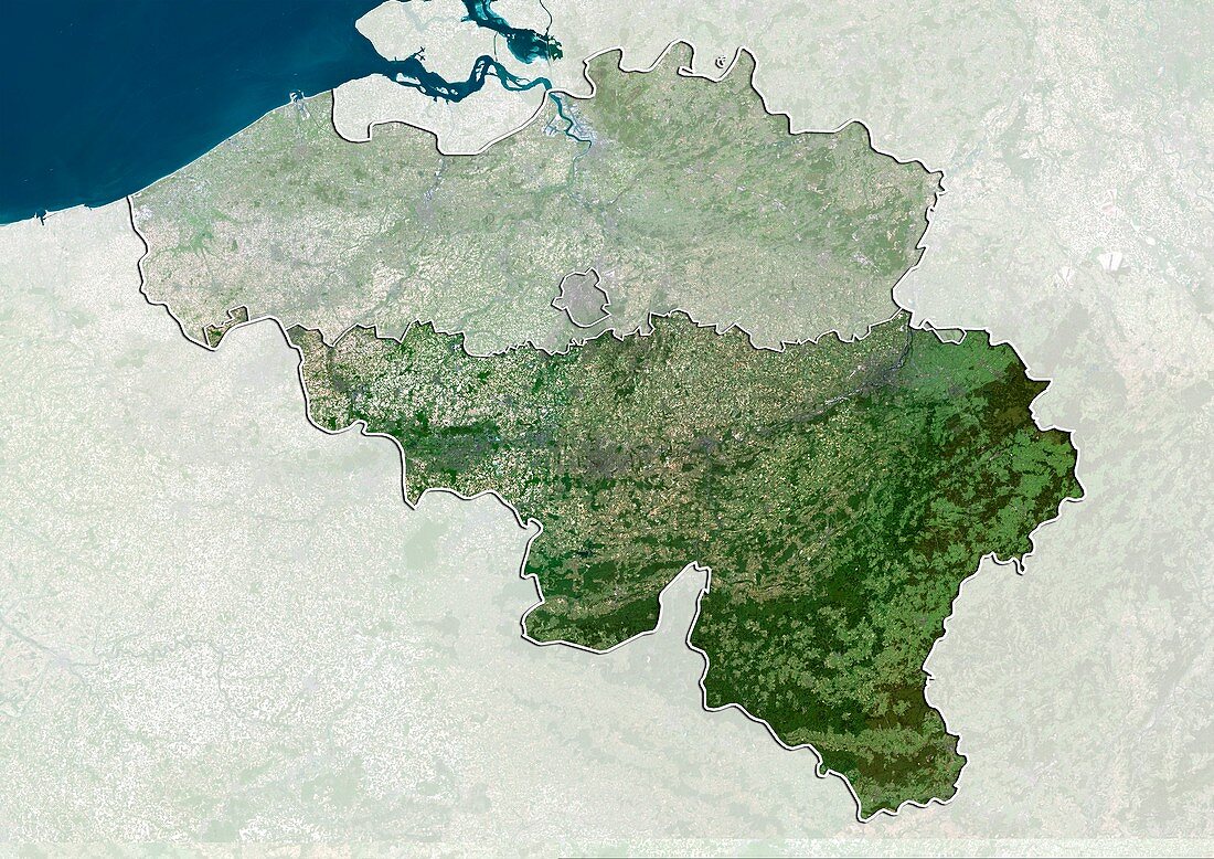
| Walloon,satellite image. North is at top. Natural colour satellite image showing the Walloon region of Belgium,with the surrounding regions shaded out. Belgium is bordered by France (lower left),Germany (right),Luxembourg (lower right),the Netherlands (Holland,top),and the North Sea (blue). It is divided into three regions: Walloon Region (Wallonia,bottom),Flemish Region (Flanders,top),and Brussels-Captial Region (Brussels,small,centre). Image compiled from data acquired by the LANDSAT 5 and 7 satellites,in 2000. Images highlighting all other regions of this country are available. For further information please contact SPL. Images highlighting all other regions of this country are available. For further information please contact SPL | |
| Lizenzart: | Lizenzpflichtig |
| Credit: | Science Photo Library / Planetobserver |
| Bildgröße: | 4978 px × 3523 px |
| Modell-Rechte: | nicht erforderlich |
| Restrictions: | - |
Preise für dieses Bild ab 15 €
Universitäten & Organisationen
(Informationsmaterial Digital, Informationsmaterial Print, Lehrmaterial Digital etc.)
ab 15 €
Redaktionell
(Bücher, Bücher: Sach- und Fachliteratur, Digitale Medien (redaktionell) etc.)
ab 30 €
Werbung
(Anzeigen, Aussenwerbung, Digitale Medien, Fernsehwerbung, Karten, Werbemittel, Zeitschriften etc.)
ab 55 €
Handelsprodukte
(bedruckte Textilie, Kalender, Postkarte, Grußkarte, Verpackung etc.)
ab 75 €
Pauschalpreise
Rechtepakete für die unbeschränkte Bildnutzung in Print oder Online
ab 495 €
Keywords
- 2000,
- 21. Jahrhundert,
- Belgien,
- belgisch,
- Deutschland,
- Erdbeobachtung,
- Europa,
- europäisch,
- Flämisch,
- Flandern,
- Frankreich,
- geografisch,
- Geographie,
- Grenze,
- Grenzen,
- Holland,
- Karte,
- Kartographie,
- Küste,
- Küsten-,
- Küstenlinie,
- Land,
- Länder,
- Landsat 7,
- Luxemburg,
- maskiert,
- Nation,
- Natur,
- Natürliche Farbe,
- Niederlande,
- Nordsee,
- Rand,
- Satellit,
- Satellitenbild,
- Staat,
- topografisch,
- Topographie,
- Ufer,
- Umwelt,
- Vogelperspektive,
- Von Oben,
- Wasser,
- Weltall,
- wolkenlos