Isle of Man,satellite image
Bildnummer 11630370
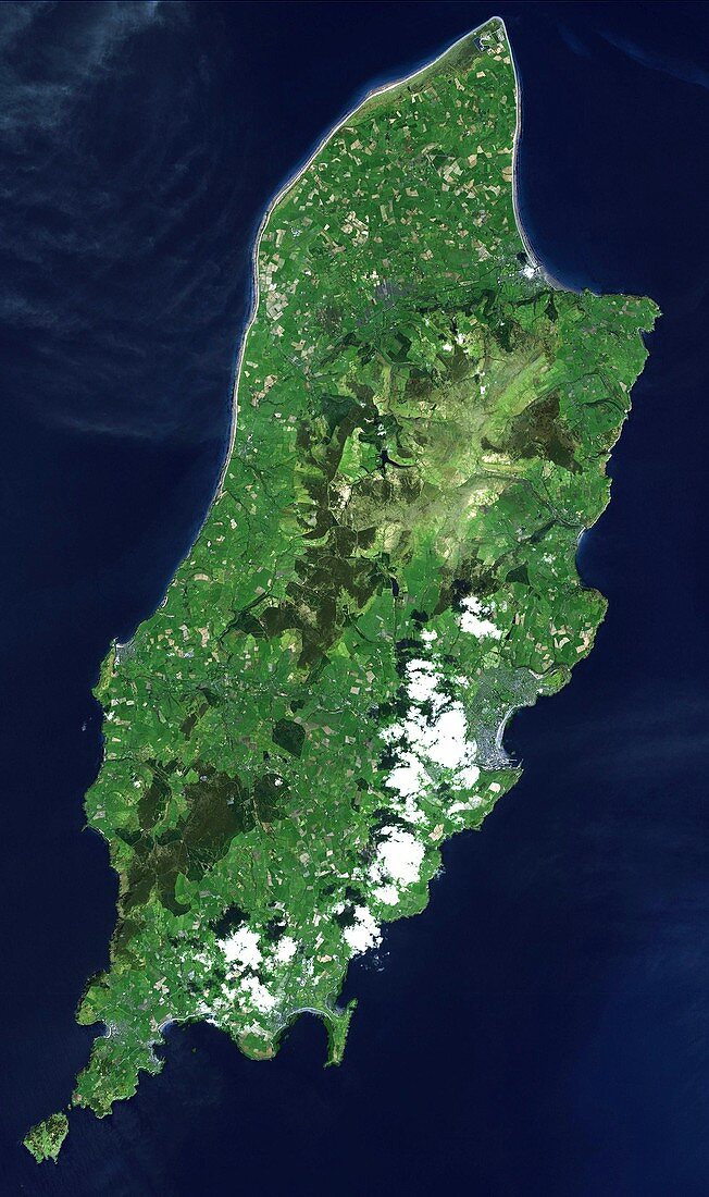
| Isle of Man,satellite image. North is towards top left. Visible features include fields and hills (shades of green),beaches and clouds (white),lakes and reservoirs (dark blue),and urban areas (grey). The Isle of Man is a self-governing British Crown Dependency in the Irish Sea between Great Britain and Ireland. It has been inhabited since 6500 BC,with a current population of around 85,000. It is 52 kilometres long,and 22 kilometres wide at its widest point. The capital and largest town is Douglas (lower right). Image obtained by the Advanced Spaceborne Thermal Emission and Reflection Radiometer (ASTER) on NASA's Terra satellite,on 1 May 2001 | |
| Lizenzart: | Lizenzpflichtig |
| Credit: | Science Photo Library / US-JAPAN ASTER SCIENCE TEAM / JAROS / ERSDAC / METI / GSFC / NASA |
| Bildgröße: | 2284 px × 3853 px |
| Modell-Rechte: | nicht erforderlich |
| Eigentums-Rechte: | nicht erforderlich |
| Restrictions: | - |
Preise für dieses Bild ab 15 €
Universitäten & Organisationen
(Informationsmaterial Digital, Informationsmaterial Print, Lehrmaterial Digital etc.)
ab 15 €
Redaktionell
(Bücher, Bücher: Sach- und Fachliteratur, Digitale Medien (redaktionell) etc.)
ab 30 €
Werbung
(Anzeigen, Aussenwerbung, Digitale Medien, Fernsehwerbung, Karten, Werbemittel, Zeitschriften etc.)
ab 55 €
Handelsprodukte
(bedruckte Textilie, Kalender, Postkarte, Grußkarte, Verpackung etc.)
ab 75 €
Pauschalpreise
Rechtepakete für die unbeschränkte Bildnutzung in Print oder Online
ab 495 €
Keywords
- 21. Jahrhundert,
- Aster,
- Bauernhöfe,
- Bodennutzung,
- britisch,
- Dorf,
- Europa,
- europäisch,
- Feld,
- Felder,
- geografisch,
- Geographie,
- Großbritannien,
- Hafen,
- Hügel,
- infrarot,
- Insel,
- Irische See,
- Isle of Man,
- Küste,
- Küsten-,
- Land,
- Landwirtschaft,
- Meer,
- menschliche Geografie,
- optisch,
- Ozean,
- Satellit,
- Satellitenbild,
- Sichtbar,
- Stadt,
- Strand,
- Strände,
- Terra,
- Terrain,
- Topographie,
- Vegetation,
- Vereinigtes Königreich,
- Wasser,
- Weltall,
- Wolke,
- Wolken