Zambia,satellite image
Bildnummer 11629579
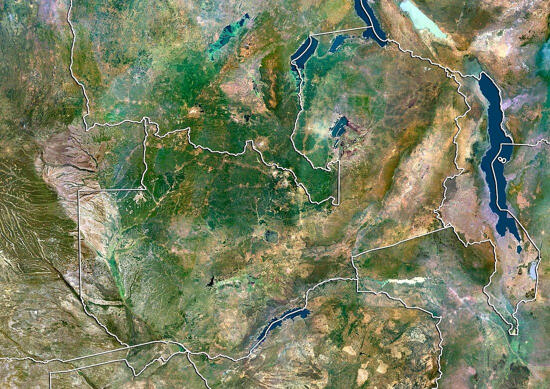
| Zambia,satellite image. North is at top. Natural colour satellite image showing Zambia (centre) and the surrounding territories. Zambia is a landlocked country in Southern Africa. It is bordered by the Democratic Republic of the Congo (DRC,upper centre),Tanzania (top right),Malawi (right),Mozambique (lower right),Zimbabwe (bottom right),Botswana (bottom left),Namibia (lower left),and Angola (left). Lake Kariba (blue,lower centre) - the world's largest artificial lake,can be seen straddling the border with Zimbabwe. Two of the African Great Lakes - Lake Malawi (blue,far right) and Lake Tanganyika (blue,top right),can also be seen. Image compiled from data acquired by the LANDSAT 5 and 7 satellites,in 2000 | |
| Lizenzart: | Lizenzpflichtig |
| Credit: | Science Photo Library / Planetobserver |
| Bildgröße: | 4919 px × 3481 px |
| Modell-Rechte: | nicht erforderlich |
| Restrictions: | - |
Preise für dieses Bild ab 15 €
Universitäten & Organisationen
(Informationsmaterial Digital, Informationsmaterial Print, Lehrmaterial Digital etc.)
ab 15 €
Redaktionell
(Bücher, Bücher: Sach- und Fachliteratur, Digitale Medien (redaktionell) etc.)
ab 30 €
Werbung
(Anzeigen, Aussenwerbung, Digitale Medien, Fernsehwerbung, Karten, Werbemittel, Zeitschriften etc.)
ab 55 €
Handelsprodukte
(bedruckte Textilie, Kalender, Postkarte, Grußkarte, Verpackung etc.)
ab 75 €
Pauschalpreise
Rechtepakete für die unbeschränkte Bildnutzung in Print oder Online
ab 495 €
Keywords
- 2000,
- 21. Jahrhundert,
- Afrika,
- Afrikanisch,
- Angola,
- Binnenstaat,
- Botswana,
- Erdbeobachtung,
- geografisch,
- Geographie,
- Grenze,
- Grenzen,
- Große Seen,
- Karte,
- Kartographie,
- Land,
- Länder,
- Landsat 7,
- Malawi,
- maskiert,
- Namibia,
- Nation,
- Natur,
- Natürliche Farbe,
- Rand,
- Satellit,
- Satellitenbild,
- Staat,
- Südafrika,
- Tansania,
- topografisch,
- Topographie,
- Umwelt,
- Vogelperspektive,
- Von Oben,
- Wasser,
- Weltall,
- Zimbabwe