Norway,satellite image
Bildnummer 11629456
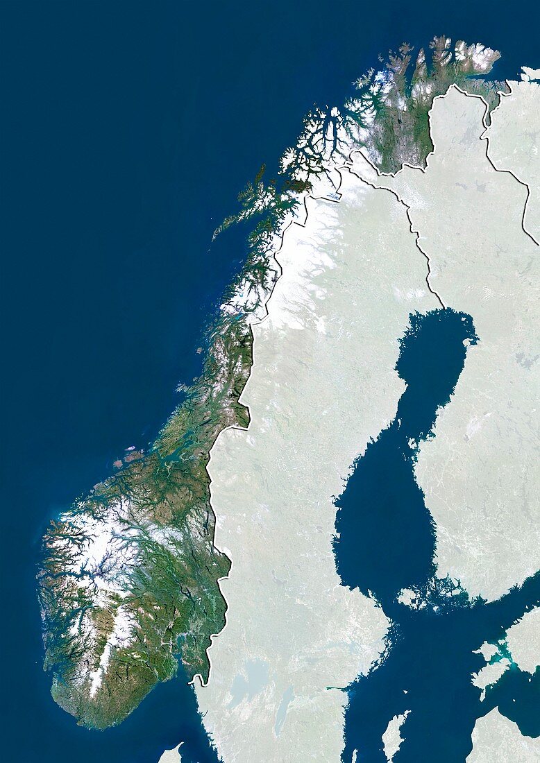
| Norway,satellite image. North is at top. Natural colour satellite image showing Norway,with the surrounding territories shaded out. Norway is a Nordic country that comprises the western portion of the Scandinavian Peninsula,Jan Mayen,the Arctic archipelago of Svalbard and the subantarctic Bouvet Island. It is bordered by Sweden (centre),Finland (centre right),and Russia (upper right). The Skagerrak Strait (blue,bottom left) separates Norway from Denmark (not seen). The North Sea (blue,lower left),Norwegian Sea (blue,centre left to upper left),Barents Sea (blue,top right),and Gulf of Bothnia (blue,centre right) - part of the Baltic Sea (blue,lower right),can also be seen. Image compiled from data acquired by the LANDSAT 5 and 7 satellites | |
| Lizenzart: | Lizenzpflichtig |
| Credit: | Science Photo Library / Planetobserver |
| Bildgröße: | 3482 px × 4920 px |
| Modell-Rechte: | nicht erforderlich |
| Restrictions: | - |
Preise für dieses Bild ab 15 €
Universitäten & Organisationen
(Informationsmaterial Digital, Informationsmaterial Print, Lehrmaterial Digital etc.)
ab 15 €
Redaktionell
(Bücher, Bücher: Sach- und Fachliteratur, Digitale Medien (redaktionell) etc.)
ab 30 €
Werbung
(Anzeigen, Aussenwerbung, Digitale Medien, Fernsehwerbung, Karten, Werbemittel, Zeitschriften etc.)
ab 55 €
Handelsprodukte
(bedruckte Textilie, Kalender, Postkarte, Grußkarte, Verpackung etc.)
ab 75 €
Pauschalpreise
Rechtepakete für die unbeschränkte Bildnutzung in Print oder Online
ab 495 €
Keywords
- 2000,
- 21. Jahrhundert,
- Erdbeobachtung,
- Europa,
- europäisch,
- Finnland,
- geografisch,
- Geographie,
- Grenze,
- Grenzen,
- Karte,
- Kartographie,
- Küste,
- Küsten-,
- Küstenlinie,
- Land,
- Länder,
- Landsat 7,
- maskiert,
- Nation,
- Natur,
- Natürliche Farbe,
- Nordeuropa,
- Nordisch,
- Nordsee,
- Norwegen,
- Ostsee,
- Rand,
- Region,
- Russland,
- Satellit,
- Satellitenbild,
- Schweden,
- Skandinavien,
- Staat,
- topografisch,
- Topographie,
- Ufer,
- Umwelt,
- Vogelperspektive,
- Von Oben,
- Wasser,
- Weltall