Malaysia,satellite image
Bildnummer 11629418
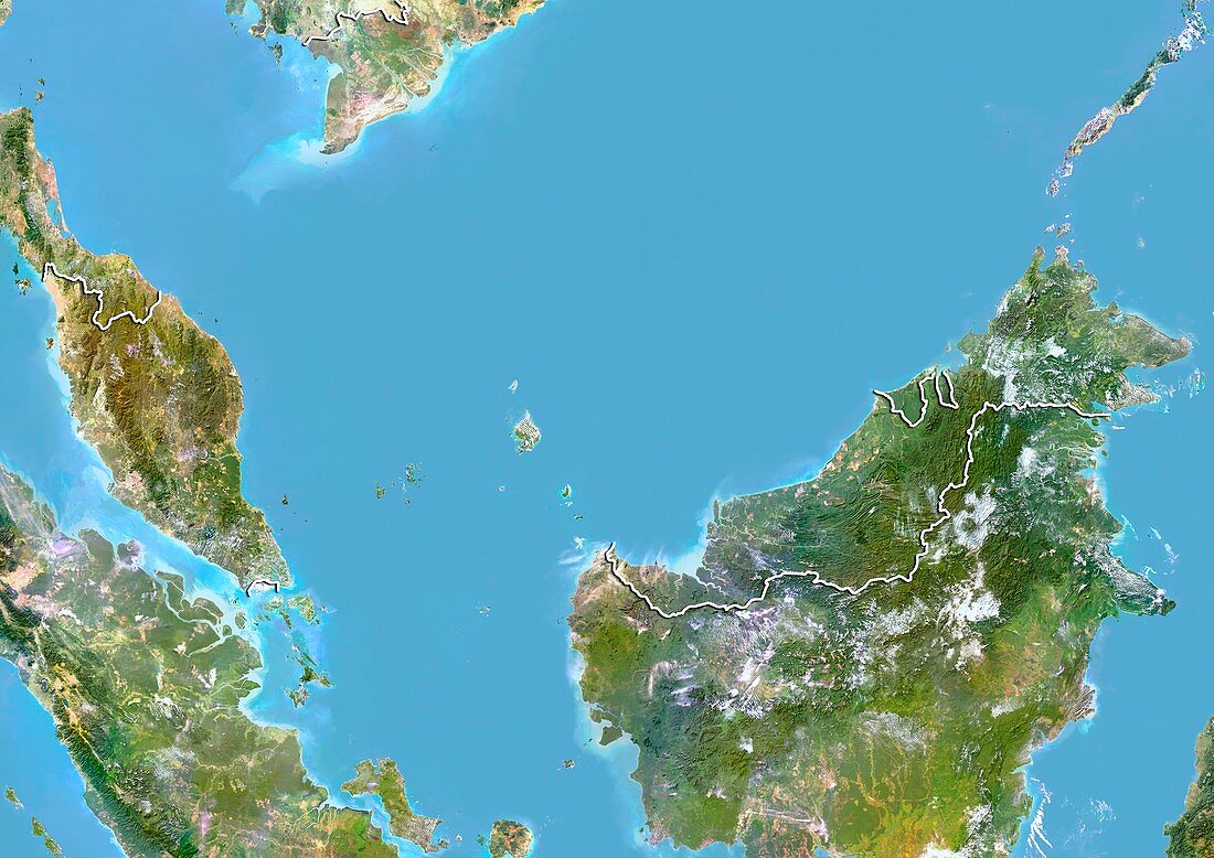
| Malaysia,satellite image. North is at top. Natural colour satellite image showing Malaysia and the surrounding territories. Malaysia lies in Southeast Asia. It consists of thirteen states and three federal territories separated by the South China Sea (blue,centre) into two similarly sized regions,Peninsular Malaysia (centre left) and Malaysian Borneo (centre right). It borders Thailand (upper left),Indonesia (lower left and lower right),and Brunei (small,centre right). Image compiled from data acquired by the LANDSAT 5 and 7 satellites,in 2000 | |
| Lizenzart: | Lizenzpflichtig |
| Credit: | Science Photo Library / Planetobserver |
| Bildgröße: | 4919 px × 3481 px |
| Modell-Rechte: | nicht erforderlich |
| Restrictions: | - |
Preise für dieses Bild ab 15 €
Universitäten & Organisationen
(Informationsmaterial Digital, Informationsmaterial Print, Lehrmaterial Digital etc.)
ab 15 €
Redaktionell
(Bücher, Bücher: Sach- und Fachliteratur, Digitale Medien (redaktionell) etc.)
ab 30 €
Werbung
(Anzeigen, Aussenwerbung, Digitale Medien, Fernsehwerbung, Karten, Werbemittel, Zeitschriften etc.)
ab 55 €
Handelsprodukte
(bedruckte Textilie, Kalender, Postkarte, Grußkarte, Verpackung etc.)
ab 75 €
Pauschalpreise
Rechtepakete für die unbeschränkte Bildnutzung in Print oder Online
ab 495 €
Keywords
- 2000,
- 21. Jahrhundert,
- Asiatisch,
- Asien,
- Erdbeobachtung,
- geografisch,
- Geographie,
- Grenze,
- Grenzen,
- Indischer Ozean,
- Indonesien,
- indopazifisch,
- Insel,
- Inseln,
- Karte,
- Kartographie,
- Küste,
- Küsten-,
- Küstenlinie,
- Land,
- Länder,
- Landsat 7,
- Malaysia,
- malaysisches borneo,
- Nation,
- Natur,
- Natürliche Farbe,
- Pazifik,
- Provinz,
- Rand,
- Satellit,
- Satellitenbild,
- Staat,
- Südchinesisches Meer,
- Südostasien,
- Thailand,
- topografisch,
- Topographie,
- Ufer,
- Umwelt,
- Vogelperspektive,
- Von Oben,
- Weltall