Hungary,satellite image
Bildnummer 11623934
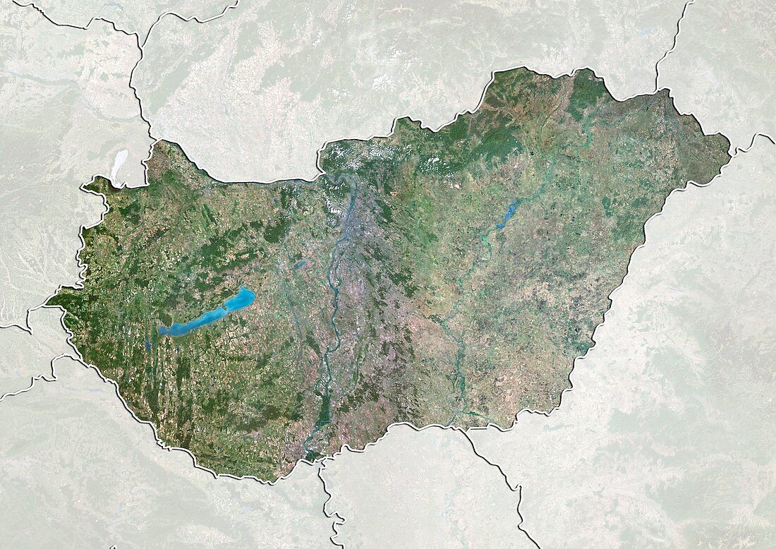
| Hungary,satellite image. North is at top. Natural colour satellite image showing Hungary,with the surrounding territories shaded out. Hungary is located in the Carpathian Basin of Central Europe. It is bordered by Slovakia (top,centre),Ukraine (upper right),Romania (lower right),Serbia (bottom centre),Croatia (bottom left),Slovenia (lower left) and Austria (upper left). Lake Balaton (blue,left),the largest lake in Central Europe,can also be seen. Image compiled from data acquired by the LANDSAT 5 and 7 satellites,in 2000 | |
| Lizenzart: | Lizenzpflichtig |
| Credit: | Science Photo Library / Planetobserver |
| Bildgröße: | 4919 px × 3481 px |
| Modell-Rechte: | nicht erforderlich |
| Restrictions: | - |
Preise für dieses Bild ab 15 €
Universitäten & Organisationen
(Informationsmaterial Digital, Informationsmaterial Print, Lehrmaterial Digital etc.)
ab 15 €
Redaktionell
(Bücher, Bücher: Sach- und Fachliteratur, Digitale Medien (redaktionell) etc.)
ab 30 €
Werbung
(Anzeigen, Aussenwerbung, Digitale Medien, Fernsehwerbung, Karten, Werbemittel, Zeitschriften etc.)
ab 55 €
Handelsprodukte
(bedruckte Textilie, Kalender, Postkarte, Grußkarte, Verpackung etc.)
ab 75 €
Pauschalpreise
Rechtepakete für die unbeschränkte Bildnutzung in Print oder Online
ab 495 €
Keywords
- 2000,
- 21. Jahrhundert,
- Erdbeobachtung,
- Europa,
- europäisch,
- geografisch,
- Geographie,
- Grenze,
- Grenzen,
- größte,
- Karte,
- Kartographie,
- Kroatien,
- Land,
- Länder,
- Landsat 7,
- maskiert,
- Nation,
- Natur,
- Natürliche Farbe,
- Österreich,
- Osteuropa,
- Rand,
- Rumänien,
- Satellit,
- Satellitenbild,
- Serbien,
- Slowakei,
- Slowenien,
- Staat,
- topografisch,
- Topographie,
- Ukraine,
- Umwelt,
- Ungarn,
- Vogelperspektive,
- Von Oben,
- Wasser,
- Weltall,
- wolkenlos