Egypt,satellite image
Bildnummer 11623886
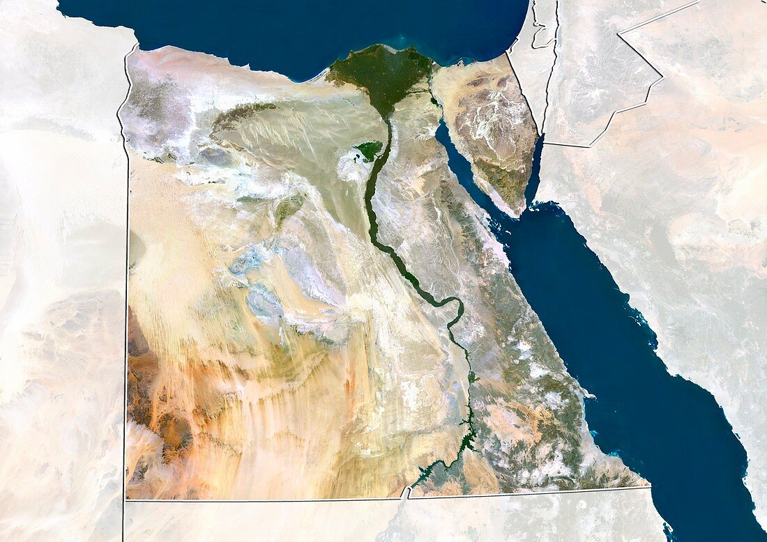
| Egypt,satellite image. North is at top. Natural colour satellite image showing Egypt,with the surrounding territories shaded out,the Mediterranean Sea (blue,top) and Red Sea (blue,right). Egypt is bordered by the Gaza Strip and Israel to the northeast,Sudan to the south and Libya to the west. The Nile river (brown,vertical) can be seen running the length of Egypt from the south to its delta (brown,upper centre) in the north. Image compiled from data acquired by the LANDSAT 5 and 7 satellites,in 2000 | |
| Lizenzart: | Lizenzpflichtig |
| Credit: | Science Photo Library / Planetobserver |
| Bildgröße: | 4919 px × 3481 px |
| Modell-Rechte: | nicht erforderlich |
| Restrictions: | - |
Preise für dieses Bild ab 15 €
Universitäten & Organisationen
(Informationsmaterial Digital, Informationsmaterial Print, Lehrmaterial Digital etc.)
ab 15 €
Redaktionell
(Bücher, Bücher: Sach- und Fachliteratur, Digitale Medien (redaktionell) etc.)
ab 30 €
Werbung
(Anzeigen, Aussenwerbung, Digitale Medien, Fernsehwerbung, Karten, Werbemittel, Zeitschriften etc.)
ab 55 €
Handelsprodukte
(bedruckte Textilie, Kalender, Postkarte, Grußkarte, Verpackung etc.)
ab 75 €
Pauschalpreise
Rechtepakete für die unbeschränkte Bildnutzung in Print oder Online
ab 495 €
Keywords
- 2000,
- 21. Jahrhundert,
- Afrika,
- Afrikanisch,
- Ägypten,
- Delta,
- Erdbeobachtung,
- Fluss,
- geografisch,
- Geographie,
- Grenze,
- Grenzen,
- Israel,
- Karte,
- Kartographie,
- Küste,
- Küsten-,
- Küstenlinie,
- Land,
- Länder,
- Landsat 7,
- maskiert,
- Mittelmeer,
- Mittlerer Osten,
- Nahost,
- Nation,
- Natur,
- Natürliche Farbe,
- Nil,
- Rand,
- Rotes Meer,
- Satellit,
- Satellitenbild,
- Staat,
- topografisch,
- Topographie,
- Ufer,
- Umwelt,
- Vogelperspektive,
- Von Oben,
- Wasser,
- Weltall,
- wolkenlos