Japanese world map,18th century
Bildnummer 11613973
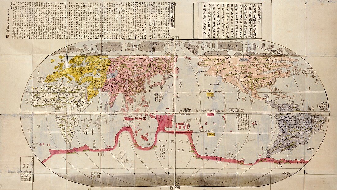
| Japanese world map. This world map,by Japanese cartographer Nagakubo Sekisui (1717-1801),dates from around 1785. It is based on the 1602 edition of Matteo Ricci's world map,which was published in China in 1584. It is a pseudocylindrical projection centred on the Pacific Ocean,with mountains shown pictorially. The main continents (Europe,Africa,Asia,the Americas) are mapped with reasonable accuracy,but the as-yet-undiscovered southern and Antarctic land masses are represented as 'Magellanica' (also known as Terra Australis). Like the Ricci map,Nagakubo's map is a wood block print. The text at top is Japanese katakana script | |
| Lizenzart: | Lizenzpflichtig |
| Credit: | Science Photo Library / Library of Congress |
| Bildgröße: | 6351 px × 3579 px |
| Modell-Rechte: | nicht erforderlich |
| Eigentums-Rechte: | nicht erforderlich |
| Restrictions: | - |
Preise für dieses Bild ab 15 €
Universitäten & Organisationen
(Informationsmaterial Digital, Informationsmaterial Print, Lehrmaterial Digital etc.)
ab 15 €
Redaktionell
(Bücher, Bücher: Sach- und Fachliteratur, Digitale Medien (redaktionell) etc.)
ab 30 €
Werbung
(Anzeigen, Aussenwerbung, Digitale Medien, Fernsehwerbung, Karten, Werbemittel, Zeitschriften etc.)
ab 55 €
Handelsprodukte
(bedruckte Textilie, Kalender, Postkarte, Grußkarte, Verpackung etc.)
ab 75 €
Pauschalpreise
Rechtepakete für die unbeschränkte Bildnutzung in Print oder Online
ab 495 €
Keywords
- 1600er Jahre,
- 17. Jahrhundert,
- 1700er Jahre,
- 18. Jahrhundert,
- Afrika,
- Afrikanisch,
- Asiatisch,
- Asien,
- Erde,
- Europa,
- europäisch,
- geografisch,
- Geographie,
- Geschichte,
- historisch,
- Illustration,
- Japan,
- Japanisch,
- Karte,
- Kartographie,
- Kunstwerk,
- Nordamerika,
- Schreiben,
- Südamerika,
- Südamerikanisch,
- Terra Australis,
- Text,
- Weltkarte