Frozen Mars,satellite image
Bildnummer 11611672
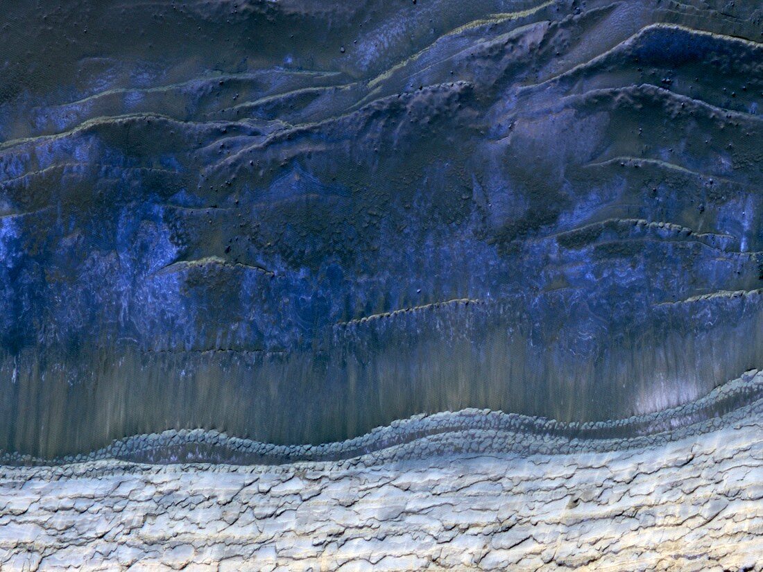
| Frozen Mars. Satellite image showing the scarp that demarcates the boundary between layered deposits covering the north polar region (blue,top) and the lower surrounding terrain,which includes sand dunes. This image was taken in the Martian spring and it is still cold enough for white carbon dioxide frost to cover most of the area. Imaged by the High Resolution Imaging Science Experiment (HiRISE) camera on NASA's Mars Reconnaissance Orbiter | |
| Lizenzart: | Lizenzpflichtig |
| Credit: | Science Photo Library / NASA / JPL / University of Arizona |
| Bildgröße: | 4850 px × 3638 px |
| Modell-Rechte: | nicht erforderlich |
| Restrictions: | - |
Preise für dieses Bild ab 15 €
Universitäten & Organisationen
(Informationsmaterial Digital, Informationsmaterial Print, Lehrmaterial Digital etc.)
ab 15 €
Redaktionell
(Bücher, Bücher: Sach- und Fachliteratur, Digitale Medien (redaktionell) etc.)
ab 30 €
Werbung
(Anzeigen, Aussenwerbung, Digitale Medien, Fernsehwerbung, Karten, Werbemittel, Zeitschriften etc.)
ab 55 €
Handelsprodukte
(bedruckte Textilie, Kalender, Postkarte, Grußkarte, Verpackung etc.)
ab 75 €
Pauschalpreise
Rechtepakete für die unbeschränkte Bildnutzung in Print oder Online
ab 495 €
Keywords
- 1,
- 2010,
- Abgrenzung,
- Astrogeologie,
- astrogeologisch,
- Astronomie,
- astronomisch,
- ausgesetzt,
- Bedeckt,
- Blau,
- Dünen,
- Eis,
- eisig,
- Formation,
- Formationen,
- Frost,
- Frühling,
- Gefroren,
- gefrorenes Kohlendioxid,
- Geologie,
- geologisch,
- Kalt,
- Mars,
- NASA,
- Norden,
- nördliche Hemisphäre,
- Planetenwissenschaft,
- Polarregion,
- Pole,
- Raum,
- Sanddüne,
- Satellitenbild,
- Schicht,
- Schichten,
- topografisch,
- Topographie,
- vom Mars,
- Weltall