Early Ordnance Survey stations,1799
Bildnummer 11602155
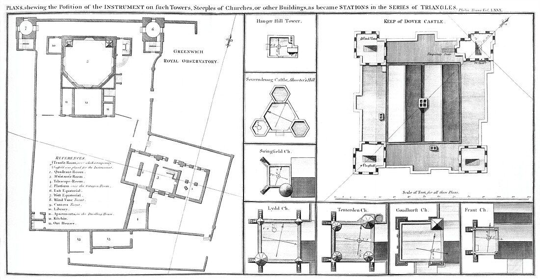
| Early Ordnance Survey stations. Diagrams of some of the triangulations stations (including Greenwich Royal Observatory and Dover Castle) used in the 1784-1796 surveys of England and Wales. The stations (usually church towers or castles) formed connected triangles (see C009/5094),and measuring the angles between them allowed accurate maps to be constructed. This work was first published in Philosophical Transactions of the Royal Society,then later in volume one of a 1799 report by Mudge and Dalby for the government's Board of Ordnance. This would eventually form the basis of the UK national mapping agency,the Ordnance Survey | |
| Lizenzart: | Lizenzpflichtig |
| Credit: | Science Photo Library / Royal Astronomical Society |
| Bildgröße: | 5870 px × 3046 px |
| Modell-Rechte: | nicht erforderlich |
| Eigentums-Rechte: | nicht erforderlich |
| Restrictions: | - |
Preise für dieses Bild ab 15 €
Universitäten & Organisationen
(Informationsmaterial Digital, Informationsmaterial Print, Lehrmaterial Digital etc.)
ab 15 €
Redaktionell
(Bücher, Bücher: Sach- und Fachliteratur, Digitale Medien (redaktionell) etc.)
ab 30 €
Werbung
(Anzeigen, Aussenwerbung, Digitale Medien, Fernsehwerbung, Karten, Werbemittel, Zeitschriften etc.)
ab 55 €
Handelsprodukte
(bedruckte Textilie, Kalender, Postkarte, Grußkarte, Verpackung etc.)
ab 75 €
Pauschalpreise
Rechtepakete für die unbeschränkte Bildnutzung in Print oder Online
ab 495 €
Keywords
- 1700er Jahre,
- 18. Jahrhundert,
- britisch,
- Diagramm,
- Einfarbig,
- England,
- Englisch,
- erst,
- Europa,
- europäisch,
- früh,
- Gebäude,
- geografisch,
- Geographie,
- Geschichte,
- Großbritannien,
- historisch,
- Illustration,
- Karte,
- Karten,
- Kartographie,
- Kirche,
- Kirchen,
- Königliche Gesellschaft,
- Kunstwerk,
- Militär-,
- nationale Agentur,
- Organisation,
- Philosophische Transaktionen,
- Planen,
- Royal Observatory Greenwich,
- Schloss,
- Schlösser,
- Schwarz und weiß,
- Tenterden,
- Trigonometrie,
- Trigonometrische Vermessung,
- Turm,
- Türme,
- Vereinigtes Königreich,
- wegweisend,
- wissenschaftlich