Faroes and Shetlands,satellite image
Bildnummer 11592948
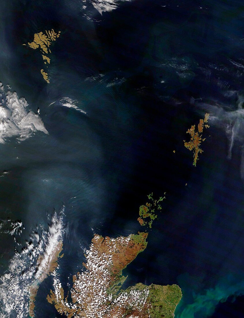
| Faroes and Shetlands,satellite image. The Faroe Islands are at top left,while the Shetland Islands are at centre right. Across bottom is the northern tip of Scotland,with islands in this region including the Orkneys and the northern islands of the Hebrides. The Orkneys are just off the northernmost tip of mainland Scotland. Clouds (white) are seen over the mainland and the Isle of Skye and the Isle of Lewis. Clouds are also seen out in the Atlantic. All the land here is Scottish,except for the Faroes,which are Danish. This image,which is several hundred kilometres across,was obtained at 12:00 UTC on 7 May 2008,by NASA's Terra satellite | |
| Lizenzart: | Lizenzpflichtig |
| Credit: | Science Photo Library / NASA |
| Bildgröße: | 3726 px × 4843 px |
| Modell-Rechte: | nicht erforderlich |
| Eigentums-Rechte: | nicht erforderlich |
| Restrictions: | - |
Preise für dieses Bild ab 15 €
Universitäten & Organisationen
(Informationsmaterial Digital, Informationsmaterial Print, Lehrmaterial Digital etc.)
ab 15 €
Redaktionell
(Bücher, Bücher: Sach- und Fachliteratur, Digitale Medien (redaktionell) etc.)
ab 30 €
Werbung
(Anzeigen, Aussenwerbung, Digitale Medien, Fernsehwerbung, Karten, Werbemittel, Zeitschriften etc.)
ab 55 €
Handelsprodukte
(bedruckte Textilie, Kalender, Postkarte, Grußkarte, Verpackung etc.)
ab 75 €
Pauschalpreise
Rechtepakete für die unbeschränkte Bildnutzung in Print oder Online
ab 495 €
Keywords
- 21. Jahrhundert,
- Archipel,
- Archipele,
- Atlantisch,
- Blütezeit,
- britisch,
- Dänemark,
- Dänisch,
- Europa,
- europäisch,
- fern,
- geografisch,
- Geographie,
- Großbritannien,
- Hagedorn,
- Insel,
- Inseln,
- Land,
- Meer,
- Natur,
- Ozean,
- Satellit,
- Satellitenbild,
- schottisch,
- Schottland,
- Skye,
- Terra,
- Vereinigtes Königreich,
- Weltall,
- Wolken