Portuguese sea chart,16th century
Bildnummer 11592260
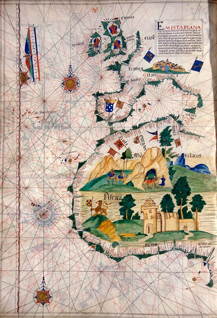
| Portuguese sea chart. 16th century nautical chart of the coastlines of Western Europe (top) and West Africa (bottom). North is at top. The chart shows the names of locations along the coastlines,and gives lines used for navigation at sea. Artworks of camels and a castle fill the African interior. Nautical charts such as these were used during the Age of Discovery,that included the 1497-9 voyage of the Portuguese explorer Vasco da Gama,which opened the maritime trading route from Europe round Africa to India. This map is from a 1563 atlas by the Portuguese cartographer Lazaro Luis,at the Sciences Academy of Lisbon | |
| Lizenzart: | Lizenzpflichtig |
| Credit: | Science Photo Library / Landmann, Patrick |
| Bildgröße: | 3452 px × 5052 px |
| Modell-Rechte: | nicht erforderlich |
| Eigentums-Rechte: | nicht erforderlich |
| Restrictions: | - |
Preise für dieses Bild ab 15 €
Universitäten & Organisationen
(Informationsmaterial Digital, Informationsmaterial Print, Lehrmaterial Digital etc.)
ab 15 €
Redaktionell
(Bücher, Bücher: Sach- und Fachliteratur, Digitale Medien (redaktionell) etc.)
ab 30 €
Werbung
(Anzeigen, Aussenwerbung, Digitale Medien, Fernsehwerbung, Karten, Werbemittel, Zeitschriften etc.)
ab 55 €
Handelsprodukte
(bedruckte Textilie, Kalender, Postkarte, Grußkarte, Verpackung etc.)
ab 75 €
Pauschalpreise
Rechtepakete für die unbeschränkte Bildnutzung in Print oder Online
ab 495 €
Keywords
- 1500er Jahre,
- 16. Jahrhundert,
- Afrika,
- Afrikanisch,
- Blatt,
- Diagramm,
- Erkundung,
- Europa,
- europäisch,
- Flagge,
- Flaggen,
- geografisch,
- Geographie,
- Geschichte,
- historisch,
- Illustration,
- Kamel,
- Kamele,
- Karte,
- Kartographie,
- Kontinent,
- Kunstwerk,
- Küste,
- Küsten-,
- Lazaro luis,
- Lissabon,
- Mann,
- Männer,
- Manuskript,
- Mensch,
- Menschen,
- Nautisch,
- Person,
- Portugal,
- Portugiesisch,
- Region,
- Tier,
- Tiere