Gulf of Mexico oil spill,2010
Bildnummer 11584133
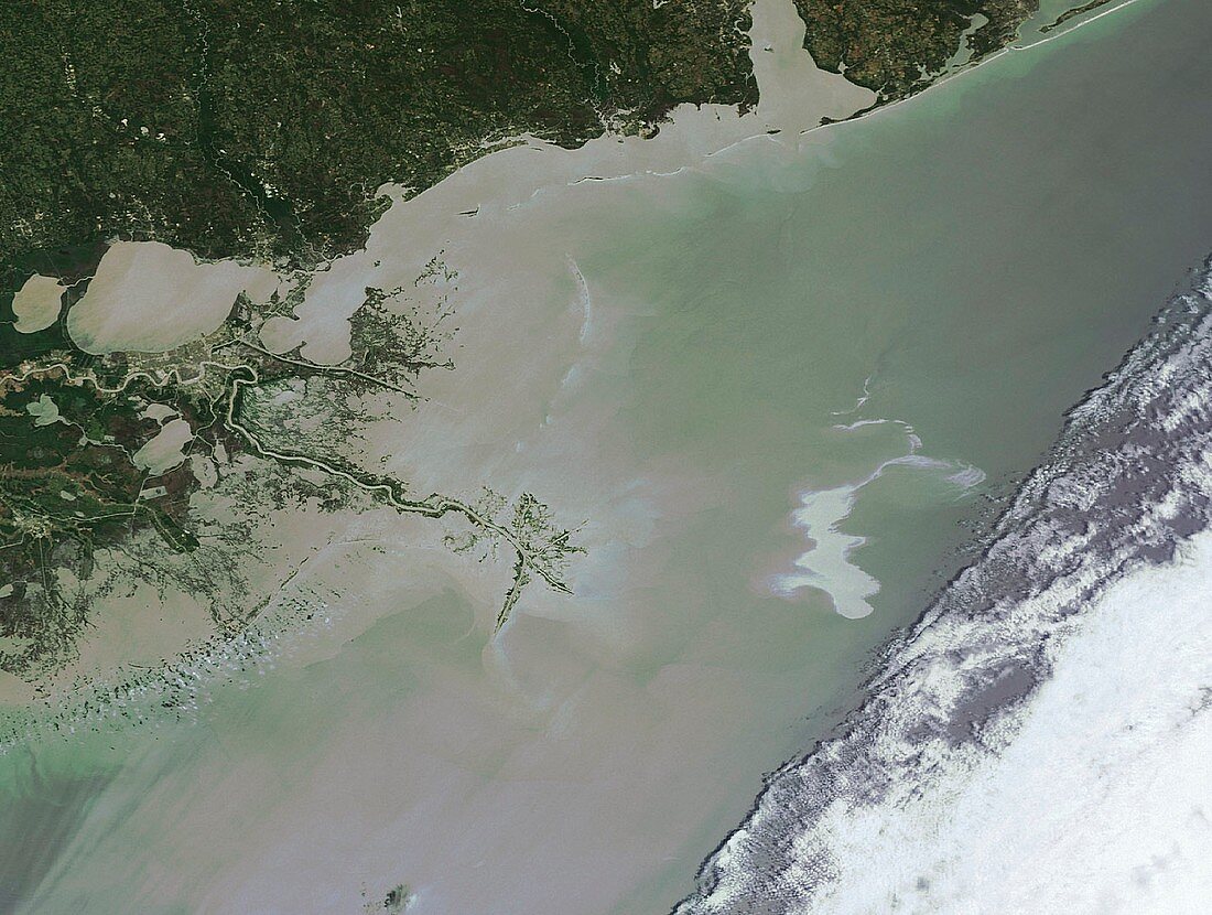
| Gulf of Mexico oil spill,2010. Satellite image of the oil spill (white,centre right) caused by the explosion of the Deepwater Horizon oil rig in the Gulf of Mexico 20th April 2010. Over five thousand barrels of oil a day leaked into the Gulf of Mexico,80 kilometres from the coast of Louisiana,USA,harming local wildlife and fishing industries. Image taken by the Medium Resolution Imaging Spectrometer (MERIS) aboard ESA's Envisat satellite,on 25th April 2010 | |
| Lizenzart: | Lizenzpflichtig |
| Credit: | Science Photo Library / ESA |
| Bildgröße: | 3414 px × 2575 px |
| Modell-Rechte: | nicht erforderlich |
| Eigentums-Rechte: | nicht erforderlich |
| Restrictions: |
|
Preise für dieses Bild ab 15 €
Universitäten & Organisationen
(Informationsmaterial Digital, Informationsmaterial Print, Lehrmaterial Digital etc.)
ab 15 €
Redaktionell
(Bücher, Bücher: Sach- und Fachliteratur, Digitale Medien (redaktionell) etc.)
ab 30 €
Werbung
(Anzeigen, Aussenwerbung, Digitale Medien, Fernsehwerbung, Karten, Werbemittel, Zeitschriften etc.)
ab 55 €
Handelsprodukte
(bedruckte Textilie, Kalender, Postkarte, Grußkarte, Verpackung etc.)
ab 75 €
Pauschalpreise
Rechtepakete für die unbeschränkte Bildnutzung in Print oder Online
ab 495 €
Keywords
- 21. Jahrhundert,
- Amerikanisch,
- Beschädigt,
- Explosion,
- Golf von Mexiko,
- Industrie,
- Industriell,
- Katastrophe,
- Kontamination,
- kontaminiert,
- Küste,
- Küstenlinie,
- Meer,
- Nordamerika,
- Ölbohrinsel,
- optisch,
- Satellit,
- Satellitenbild,
- Schaden,
- umweltverschmutzend,
- Umweltwissenschaften,
- Unfall,
- uns,
- USA,
- Vereinigte Staaten,
- verschmutzt,
- Verschmutzung,
- Verschütten,
- Wasser,
- Weltall