Lituya Bay 1958 tsunami landslide
Bildnummer 11571011
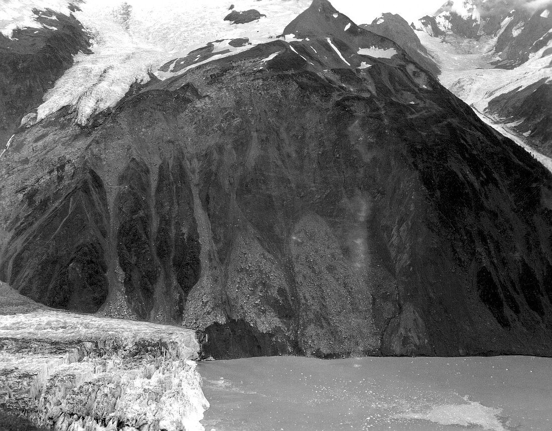
| Lituya Bay 1958 tsunami landslide. Aerial photograph from August 1958 of the scar left behind following the landslide that caused the tsunami in Lituya Bay,Alaska,USA,on 9 July 1958. This narrow bay is subject to tsunamis caused by landslides from the surrounding mountains. The tsunami reached a height of 524 metres,and was the largest ever recorded. It was caused by a landslide of 30 million cubic metres of rock,loosened from this mountainside by an earthquake. This image is part of a series taken by D.J. Miller of the United States Geological Survey,showing the area before and after the 1958 tsunami | |
| Lizenzart: | Lizenzpflichtig |
| Credit: | Science Photo Library / US Geological Survey |
| Bildgröße: | 5408 px × 4224 px |
| Modell-Rechte: | nicht erforderlich |
| Eigentums-Rechte: | nicht erforderlich |
| Restrictions: | - |
Preise für dieses Bild ab 15 €
Universitäten & Organisationen
(Informationsmaterial Digital, Informationsmaterial Print, Lehrmaterial Digital etc.)
ab 15 €
Redaktionell
(Bücher, Bücher: Sach- und Fachliteratur, Digitale Medien (redaktionell) etc.)
ab 30 €
Werbung
(Anzeigen, Aussenwerbung, Digitale Medien, Fernsehwerbung, Karten, Werbemittel, Zeitschriften etc.)
ab 55 €
Handelsprodukte
(bedruckte Textilie, Kalender, Postkarte, Grußkarte, Verpackung etc.)
ab 75 €
Pauschalpreise
Rechtepakete für die unbeschränkte Bildnutzung in Print oder Online
ab 495 €
Keywords
- 1900er Jahre,
- 20. Jahrhundert,
- Alaska,
- Amerikanisch,
- Baum,
- Berg,
- Berge,
- Bergkette,
- Beschädigt,
- Beweis,
- Bucht,
- Einfarbig,
- Erdbeben,
- Erdrutsch,
- Flora,
- Forschung,
- Geologie,
- geologisch,
- Geschichte,
- groß,
- historisch,
- Holz,
- Küste,
- Küsten-,
- Küstenlinie,
- Luftaufnahme,
- Luftaufnahmen,
- massiv,
- Megatsunami,
- Natur,
- Naturkatastrophe,
- Nordamerika,
- nordamerikanisch,
- Schaden,
- Schwarz und weiß,
- Seismologie,
- uns,
- USA,
- Vereinigte Staaten,
- Verwüstung,
- Vogelperspektive,
- Wald,
- Wasser,
- Weltgrößtes,
- Zerstörung,
- zestört