Martian landslides
Bildnummer 11569082
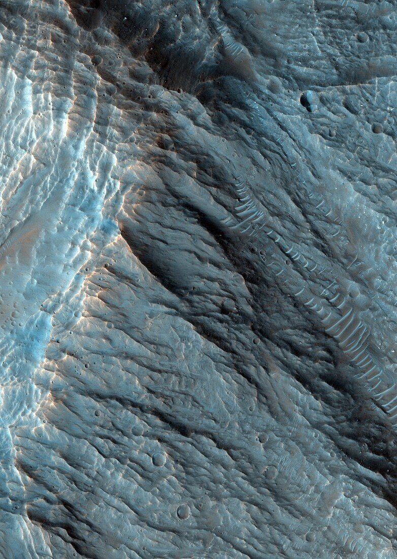
| Martian landslides. Coloured satellite image of landslides (upper middle to lower right) in the Ganges Chasma region of Mars. The Ganges Chasma is a deep canyon in the huge Valles Marineris system on Mars. The right wall of the ridge has a series of terraces (pale transverse lines) which is where large portions of debris have collected into an 'apron' during a landslide. Image obtained by the High Resolution Imaging Science Experiment (HiRISE) camera on NASA's Mars Reconnaissance Orbiter (MRO) on 22nd May 2009. The width of this image is roughly 1.1 kilometres across | |
| Lizenzart: | Lizenzpflichtig |
| Credit: | Science Photo Library / NASA / JPL / University of Arizona |
| Bildgröße: | 2024 px × 2848 px |
| Modell-Rechte: | nicht erforderlich |
| Eigentums-Rechte: | nicht erforderlich |
| Restrictions: | - |
Preise für dieses Bild ab 15 €
Universitäten & Organisationen
(Informationsmaterial Digital, Informationsmaterial Print, Lehrmaterial Digital etc.)
ab 15 €
Redaktionell
(Bücher, Bücher: Sach- und Fachliteratur, Digitale Medien (redaktionell) etc.)
ab 30 €
Werbung
(Anzeigen, Aussenwerbung, Digitale Medien, Fernsehwerbung, Karten, Werbemittel, Zeitschriften etc.)
ab 55 €
Handelsprodukte
(bedruckte Textilie, Kalender, Postkarte, Grußkarte, Verpackung etc.)
ab 75 €
Pauschalpreise
Rechtepakete für die unbeschränkte Bildnutzung in Print oder Online
ab 495 €
Keywords
- 21. Jahrhundert,
- Einlagen,
- Erdrutsch,
- Felsen,
- Felsig,
- geografisch,
- Geographie,
- Geologie,
- geologisch,
- Grat,
- HiRISE,
- hochauflösende Bildgebung,
- Mars,
- MRO,
- NASA,
- Oberfläche,
- Planetenwissenschaft,
- Satellitenbild,
- Schlucht,
- Schürze,
- Schürzen,
- Sediment,
- Sonnensystem,
- Steigung,
- Terrasse,
- Terrassen,
- Trümmer,
- Valles Marineris,
- vom Mars,
- Weltall,
- Weltraummission