Strait of Gibraltar,satellite image
Bildnummer 11566634
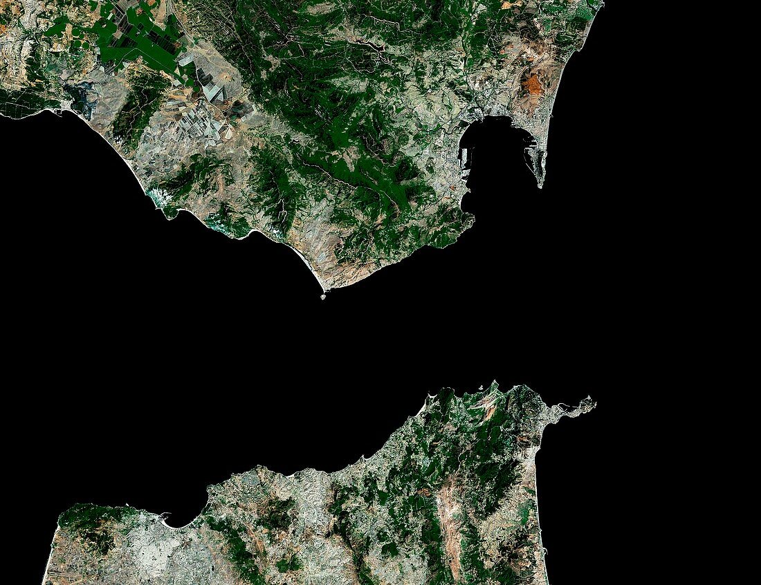
| Strait of Gibraltar,satellite image. North is at top. The Strait of Gibraltar separates Spain (top) from Africa (bottom),and joins the Mediterranean Sea (right) to the Atlantic Ocean (left). It runs between the southern tip of Gibraltar and northern tip of Tangiers,Morocco. It was known as the Pillars of Hercules in the ancient world. Forested areas are dark green,bare ground is brown,urban areas are grey,and water is black. Image created using NaturalVue data obtained from the Landsat 7 satellite | |
| Lizenzart: | Lizenzpflichtig |
| Credit: | Science Photo Library / MDA Information Systems |
| Bildgröße: | 4791 px × 3685 px |
| Modell-Rechte: | nicht erforderlich |
| Eigentums-Rechte: | nicht erforderlich |
| Restrictions: | - |
Preise für dieses Bild ab 15 €
Universitäten & Organisationen
(Informationsmaterial Digital, Informationsmaterial Print, Lehrmaterial Digital etc.)
ab 15 €
Redaktionell
(Bücher, Bücher: Sach- und Fachliteratur, Digitale Medien (redaktionell) etc.)
ab 30 €
Werbung
(Anzeigen, Aussenwerbung, Digitale Medien, Fernsehwerbung, Karten, Werbemittel, Zeitschriften etc.)
ab 55 €
Handelsprodukte
(bedruckte Textilie, Kalender, Postkarte, Grußkarte, Verpackung etc.)
ab 75 €
Pauschalpreise
Rechtepakete für die unbeschränkte Bildnutzung in Print oder Online
ab 495 €
Keywords
- Afrika,
- Afrikanisch,
- Atlantischer Ozean,
- Berg,
- britisches Überseegebiet,
- Erdbeobachtung,
- Europa,
- europäisch,
- geografisch,
- Geographie,
- Hafen,
- Küste,
- Küsten-,
- Küstenlinie,
- Landsat 7,
- Marokkanisch,
- Marokko,
- Meer,
- Mittelmeer,
- NASA,
- NaturalVue,
- Natürliche Farbe,
- Ozean,
- Satellit,
- Satellitenbild,
- Spanien,
- spanisch,
- Stadt,
- städtisch,
- Straße von Gibraltar,
- Urbanisierung,
- Vegetation,
- Vesuv,
- Wald,
- Wälder,
- Wasser,
- Weltall