Tectonic map of Asia
Bildnummer 11558455
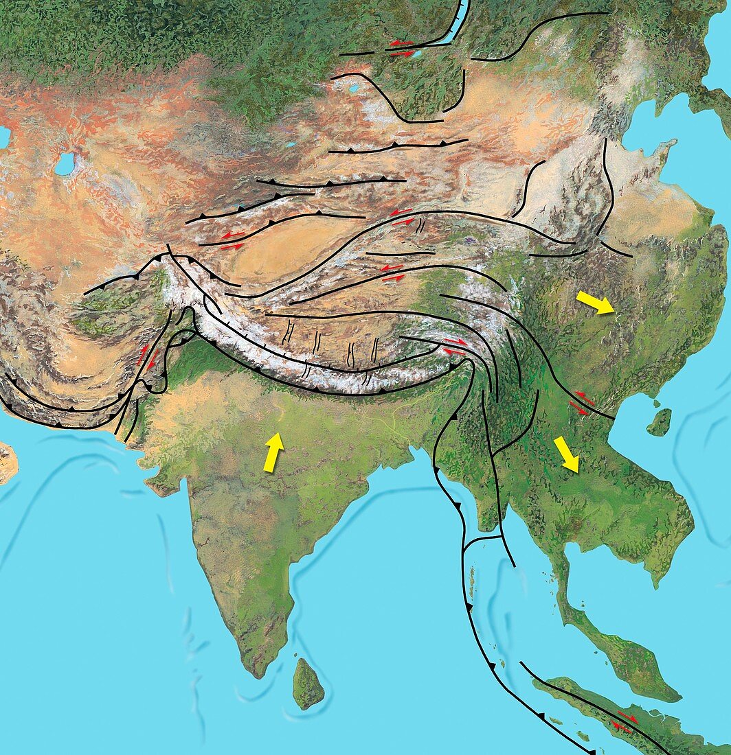
| Tectonic map of Asia. Computer artwork showing the direction of tectonic plate movements (yellow arrows) and collision zones (black toothed lines) in Asia. The World's landmasses are continually moving (plate tectonics). Until around 10 million years ago India (lower centre) was an island. As it collided with Asia,the force pushed up the Himalayas (white,lower centre) and squeezed parts of China (right) and Southeast Asia (lower right) eastwards. The collision probably caused reverse faults (small red arrows) which uplifted the Tien Shan mountains (white and brown,upper centre) | |
| Lizenzart: | Lizenzpflichtig |
| Credit: | Science Photo Library / Hks, Gary |
| Bildgröße: | 4126 px × 4264 px |
| Modell-Rechte: | nicht erforderlich |
| Eigentums-Rechte: | nicht erforderlich |
| Restrictions: | - |
Preise für dieses Bild ab 15 €
Universitäten & Organisationen
(Informationsmaterial Digital, Informationsmaterial Print, Lehrmaterial Digital etc.)
ab 15 €
Redaktionell
(Bücher, Bücher: Sach- und Fachliteratur, Digitale Medien (redaktionell) etc.)
ab 30 €
Werbung
(Anzeigen, Aussenwerbung, Digitale Medien, Fernsehwerbung, Karten, Werbemittel, Zeitschriften etc.)
ab 55 €
Handelsprodukte
(bedruckte Textilie, Kalender, Postkarte, Grußkarte, Verpackung etc.)
ab 75 €
Pauschalpreise
Rechtepakete für die unbeschränkte Bildnutzung in Print oder Online
ab 495 €
Keywords
- Antike,
- Asiatisch,
- Asien,
- Berge,
- Bergkette,
- Bewegung,
- China,
- Diagramm,
- Docking,
- geografisch,
- Geographie,
- Geologie,
- geologisch,
- Geschichte,
- Himalaya,
- historisch,
- Illustration,
- Indien,
- Indisch,
- Indischer Ozean,
- Karte,
- Kunstwerk,
- Meer,
- Pfeil,
- Pfeile,
- Plattentektonik,
- prähistorisch,
- Südostasien,
- Tibet,
- Vorgeschichte,
- Wasser,
- Zeit,
- Zonen