1715 solar eclipse,historical map
Bildnummer 11549422
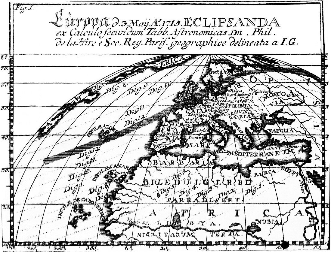
| 1715 solar eclipse. Historical map showing the path of the shadow of totality of the solar eclipse of 3rd May 1715. North Africa can be seen at the bottom of the image with Europe at centre. The shadow can be seen passing along the atlantic ocean,across the south of the Azores (centre left). It continues over Europe across the south of England (centre),north of France,then Sweden and Norway before passing over the far north of Russia (upper left). Publications like this (broadsides) were intended to make astronomical events accessible to everyday people,and to publicise the work of the scientists and publishers involved | |
| Lizenzart: | Lizenzpflichtig |
| Credit: | Science Photo Library / Royal Astronomical Society |
| Bildgröße: | 4793 px × 3685 px |
| Modell-Rechte: | nicht erforderlich |
| Eigentums-Rechte: | nicht erforderlich |
| Restrictions: | - |
Preise für dieses Bild ab 15 €
Universitäten & Organisationen
(Informationsmaterial Digital, Informationsmaterial Print, Lehrmaterial Digital etc.)
ab 15 €
Redaktionell
(Bücher, Bücher: Sach- und Fachliteratur, Digitale Medien (redaktionell) etc.)
ab 30 €
Werbung
(Anzeigen, Aussenwerbung, Digitale Medien, Fernsehwerbung, Karten, Werbemittel, Zeitschriften etc.)
ab 55 €
Handelsprodukte
(bedruckte Textilie, Kalender, Postkarte, Grußkarte, Verpackung etc.)
ab 75 €
Pauschalpreise
Rechtepakete für die unbeschränkte Bildnutzung in Print oder Online
ab 495 €
Keywords
- 1700er Jahre,
- 18. Jahrhundert,
- Afrika,
- Afrikanisch,
- Astronomie,
- astronomisch,
- Atlantischer Ozean,
- Azoren,
- britisch,
- Deutsche,
- Diagramm,
- Dunkel,
- Dunkelheit,
- Einfarbig,
- England,
- Englisch,
- Europa,
- europäisch,
- Frankreich,
- Frühling,
- Geschichte,
- Geschichte der Wissenschaft,
- Gravur,
- Großbritannien,
- historisch,
- Illustration,
- Karte,
- Kartographie,
- Kunstwerk,
- Latein,
- Pfad,
- Schatten,
- Schwarz und weiß,
- Schweden,
- Skandinavien,
- Skandinavisch,
- Sonnenfinsternis,
- Spur,
- Vereinigtes Königreich