Map of Roman Britain
Bildnummer 11687452
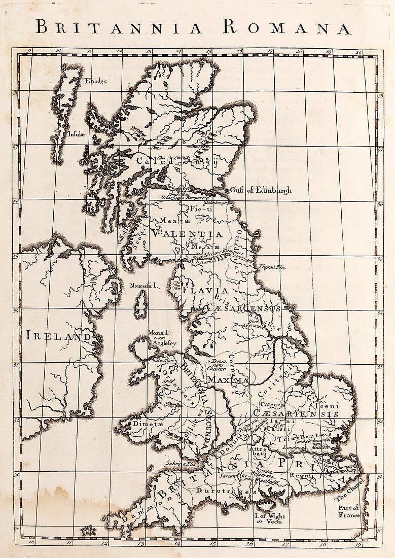
| Map of Roman Britain. 18th-century map of the Roman Empire's province in the British Isles (AD 43 to AD 409),including tribal names. The northern boundary is shown as Agricola's Fort and the rampart constructed by Lollius Urbicus (better known as the Antonine Wall). Further south is Adrian's Rampart and Severus's Wall (i.e. Hadrian's Wall). The four provinces (dating from 293 to 409) are: Britannia Prima,Britannia Secunda,Flavia Caesariensis,and Maxima Caesariensis. Between the walls is Valentia. In the far north is Caledonia. Ireland is at left. Map from 'A General History of England' (1744-1751) by British historian William Guthrie (1708-1770) | |
| Lizenzart: | Lizenzpflichtig |
| Credit: | Science Photo Library / Middle Temple Library |
| Bildgröße: | 3705 px × 5232 px |
| Modell-Rechte: | nicht erforderlich |
| Eigentums-Rechte: | nicht erforderlich |
| Restrictions: | - |
Preise für dieses Bild ab 15 €
Universitäten & Organisationen
(Informationsmaterial Digital, Informationsmaterial Print, Lehrmaterial Digital etc.)
ab 15 €
Redaktionell
(Bücher, Bücher: Sach- und Fachliteratur, Digitale Medien (redaktionell) etc.)
ab 30 €
Werbung
(Anzeigen, Aussenwerbung, Digitale Medien, Fernsehwerbung, Karten, Werbemittel, Zeitschriften etc.)
ab 55 €
Handelsprodukte
(bedruckte Textilie, Kalender, Postkarte, Grußkarte, Verpackung etc.)
ab 75 €
Pauschalpreise
Rechtepakete für die unbeschränkte Bildnutzung in Print oder Online
ab 495 €
Keywords
- 1700er Jahre,
- 18. Jahrhundert,
- Agricola,
- Anglesey,
- Antike,
- Äußere Hebriden,
- Blatt,
- britisch,
- Britische Inseln,
- Buch,
- Canterbury,
- Chester,
- Colchester,
- Einfarbig,
- England,
- Englisch,
- europäisch,
- geografisch,
- Geographie,
- Geschichte,
- Grenze,
- Grenzen,
- Hadrian,
- historisch,
- Illustration,
- Irisch,
- Irland,
- Isle of Man,
- Karte,
- Kartographie,
- keltisch,
- klassisch,
- Kunstwerk,
- Land,
- London,
- Mauer,
- Mona,
- Niemand,
- Provinz,
- Regel,
- Römisch,
- Römisches Reich,
- schottisch,
- Schottland,
- Schwarz und weiß,
- Veröffentlichung,
- Wales,
- Walisisch,
- Wall,
- Wände,
- William Guthrie,
- Winchester,
- York