Loire River, France, over three years, satellite images
Bildnummer 13765215
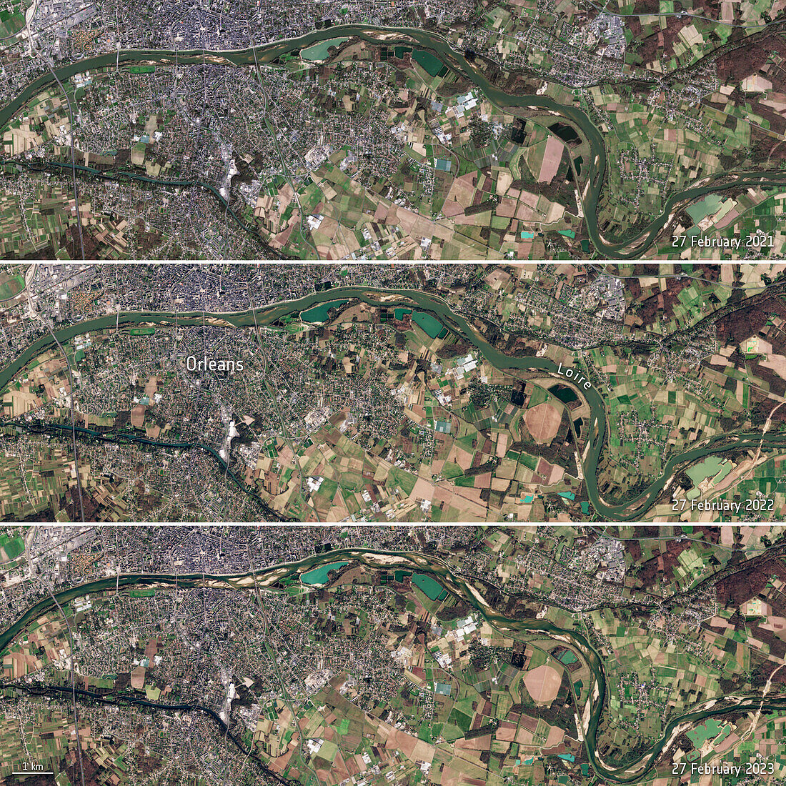
| Satellite images of the Loire River, near Orleans, France on the 27th February 2021 (top), 2022 (middle) and 2023 (bottom). There are large areas of exposed riverbed in the image from 2023 due to drought. The drought was caused by the second warmest winter on record with low levels of rainfall. Data obtained by the Copernicus Sentinel-2 satellite. | |
| Lizenzart: | Lizenzpflichtig |
| Credit: | Science Photo Library / ESA |
| Bildgröße: | 1920 px × 1920 px |
| Modell-Rechte: | nicht erforderlich |
| Eigentums-Rechte: | nicht erforderlich |
| Restrictions: |
|
Preise für dieses Bild ab 15 €
Universitäten & Organisationen
(Informationsmaterial Digital, Informationsmaterial Print, Lehrmaterial Digital etc.)
ab 15 €
Redaktionell
(Bücher, Bücher: Sach- und Fachliteratur, Digitale Medien (redaktionell) etc.)
ab 30 €
Werbung
(Anzeigen, Aussenwerbung, Digitale Medien, Fernsehwerbung, Karten, Werbemittel, Zeitschriften etc.)
ab 55 €
Handelsprodukte
(bedruckte Textilie, Kalender, Postkarte, Grußkarte, Verpackung etc.)
ab 75 €
Pauschalpreise
Rechtepakete für die unbeschränkte Bildnutzung in Print oder Online
ab 495 €
Keywords
- 2000er Jahre,
- 21. Jahrhundert,
- beschriftet,
- Dürre,
- Etikette,
- Etiketten,
- Europa,
- europäisch,
- Fluss,
- Flussbett,
- Frankreich,
- Französisch,
- getrocknet,
- Globale Erwärmung,
- Hydrologie,
- Klima,
- Klimawandel,
- Loire,
- Meteorologie,
- meteorologisch,
- Niemand,
- Orleans,
- Satellitenbild,
- Text,
- Trocken,
- Umwelt,
- Vergleich,
- vergleichen,
- Wasser,
- Weltall,
- Wetter