Extent of river ice between 1984 and 2018, illustration
Bildnummer 13403679
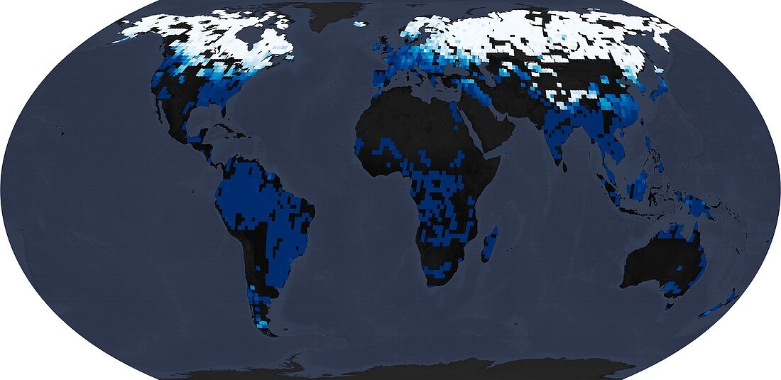
| Map showing the extent of river ice in the northern hemisphere winter (December, January, and February) and the southern hemisphere winter (June, July, and August). Data was obtained from Landsat satellite between 1984 and 2018. White represents 100% river ice and the darkest blue represents 0% river ice coverage. The vast majority of ice-covered rivers are found in the Northern Hemisphere; just a few rivers were found with seasonal ice south of the equator (in New Zealand, Patagonia, and Australia). The analysis only includes rivers wider than 90 metres. | |
| Lizenzart: | Lizenzpflichtig |
| Credit: | Science Photo Library / US Geological Survey / Yang, X., et al. (2020) / NASA Earth Observatory, Joshua Stevens |
| Bildgröße: | 4479 px × 2179 px |
| Modell-Rechte: | nicht erforderlich |
| Eigentums-Rechte: | nicht erforderlich |
| Restrictions: | - |
Preise für dieses Bild ab 15 €
Universitäten & Organisationen
(Informationsmaterial Digital, Informationsmaterial Print, Lehrmaterial Digital etc.)
ab 15 €
Redaktionell
(Bücher, Bücher: Sach- und Fachliteratur, Digitale Medien (redaktionell) etc.)
ab 30 €
Werbung
(Anzeigen, Aussenwerbung, Digitale Medien, Fernsehwerbung, Karten, Werbemittel, Zeitschriften etc.)
ab 55 €
Handelsprodukte
(bedruckte Textilie, Kalender, Postkarte, Grußkarte, Verpackung etc.)
ab 75 €
Pauschalpreise
Rechtepakete für die unbeschränkte Bildnutzung in Print oder Online
ab 495 €