Camp Fire,California,November 2018,satellite image
Bildnummer 12961544
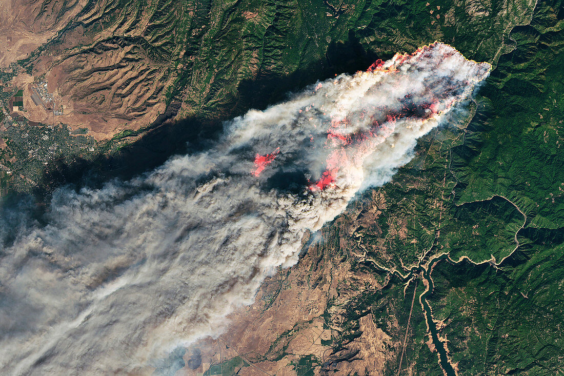
| Camp Fire,California,November 2018,combined visible and infrared satellite image. North is at top. This fire,the deadliest and most destructive in California history,broke out on 8 November 2018. The fire consumed tens of thousands of acres of land,and resulted in 85 fatalities. The active fire areas (imaged in shortwave-infrared light) are orange. The visible image data was obtained using Landsat bands 4-3-2. This image,some 50 kilometres across,is from the Operational Land Imager (OLI) on the Landsat 8 satellite. It was obtained at around 10:45 local time (18:45 UTC) on 8 November 2018,around four hours after the fire had started. | |
| Lizenzart: | Lizenzpflichtig |
| Credit: | Science Photo Library / NASA Earth Observatory |
| Bildgröße: | 5121 px × 3413 px |
| Modell-Rechte: | nicht erforderlich |
| Eigentums-Rechte: | nicht erforderlich |
| Restrictions: | - |
Preise für dieses Bild ab 15 €
Universitäten & Organisationen
(Informationsmaterial Digital, Informationsmaterial Print, Lehrmaterial Digital etc.)
ab 15 €
Redaktionell
(Bücher, Bücher: Sach- und Fachliteratur, Digitale Medien (redaktionell) etc.)
ab 30 €
Werbung
(Anzeigen, Aussenwerbung, Digitale Medien, Fernsehwerbung, Karten, Werbemittel, Zeitschriften etc.)
ab 55 €
Handelsprodukte
(bedruckte Textilie, Kalender, Postkarte, Grußkarte, Verpackung etc.)
ab 75 €
Pauschalpreise
Rechtepakete für die unbeschränkte Bildnutzung in Print oder Online
ab 495 €
Keywords
- 2018,
- 21. Jahrhundert,
- Amerikanisch,
- Erdbeobachtung,
- Erdkunde,
- Feuer,
- Flammen,
- Gefahr,
- geografisch,
- Geographie,
- Geowissenschaften,
- infrarot,
- Kalifornien,
- Lagerfeuer,
- Landsat 8,
- Naturkatastrophe,
- Niemand,
- Nordamerika,
- nordamerikanisch,
- oli,
- optisch,
- Rauch,
- Satellit,
- Satellitenbild,
- Sichtbar,
- tödlich,
- USA,
- Verbrennung,
- Vereinigte Staaten,
- Weltall,
- Zerstörung