Gaia's first sky map
Bildnummer 12099699
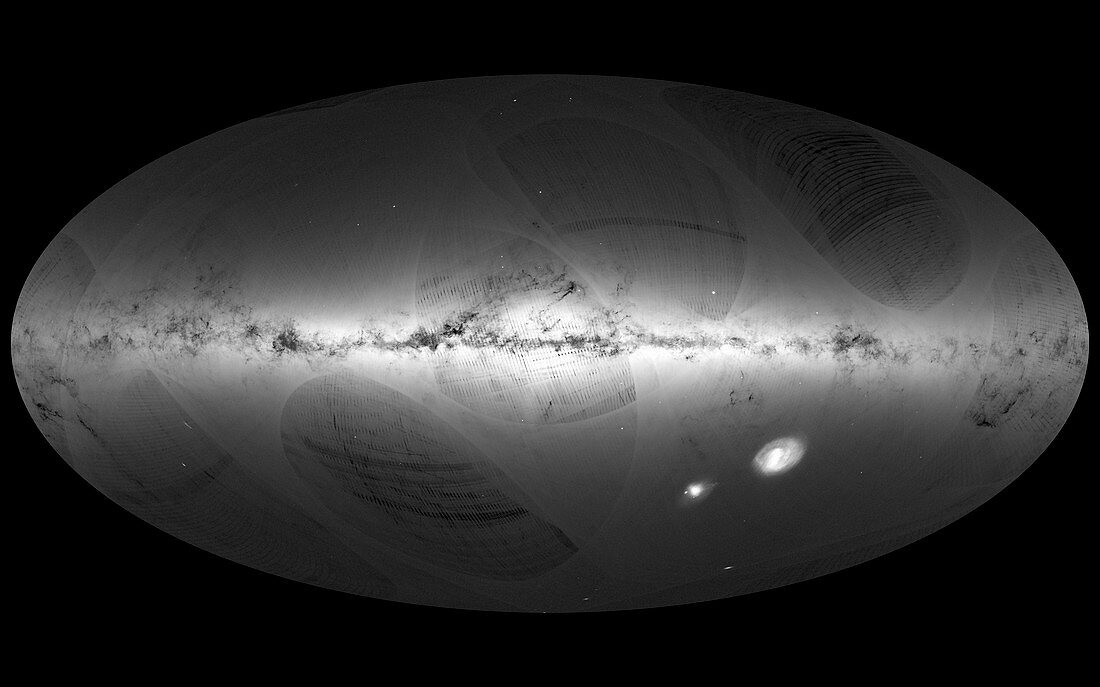
| All-sky map of our galaxy,the Milky Way,and its neighbouring galaxies made from the first year of observations of the European Space Agency's Gaia satellite. The map shows the density of stars,with brighter regions indicating denser concentrations of stars and darker regions areas where there are fewer stars. The Galactic Plane of the Milky Way is seen across centre. This is about 100,000 light years across and about 1000 light years thick. The two bright areas at lower right are the dwarf galaxies the Large and Small Magellanic Clouds. At lower left is the spiral Andromeda galaxy (M31),with its satellite the Triangulum galaxy (M33) below it. Dark stripes and curved structures within the image are scanning artefacts that will be filled in as Gaia collects more data. Gaia is located at the second Lagrangian point (L2),about 1.6 million kilometres from Earth in the direction opposite to the Sun. Observations taken between July 2014 and September 2015 | |
| Lizenzart: | Lizenzpflichtig |
| Credit: | Science Photo Library / DPAC / Gaia / ESA |
| Bildgröße: | 3842 px × 2401 px |
| Modell-Rechte: | nicht erforderlich |
| Eigentums-Rechte: | nicht erforderlich |
| Restrictions: |
|
Preise für dieses Bild ab 15 €
Universitäten & Organisationen
(Informationsmaterial Digital, Informationsmaterial Print, Lehrmaterial Digital etc.)
ab 15 €
Redaktionell
(Bücher, Bücher: Sach- und Fachliteratur, Digitale Medien (redaktionell) etc.)
ab 30 €
Werbung
(Anzeigen, Aussenwerbung, Digitale Medien, Fernsehwerbung, Karten, Werbemittel, Zeitschriften etc.)
ab 55 €
Handelsprodukte
(bedruckte Textilie, Kalender, Postkarte, Grußkarte, Verpackung etc.)
ab 75 €
Pauschalpreise
Rechtepakete für die unbeschränkte Bildnutzung in Print oder Online
ab 495 €