Map of Ancient Palestine,19th century
Bildnummer 11946680
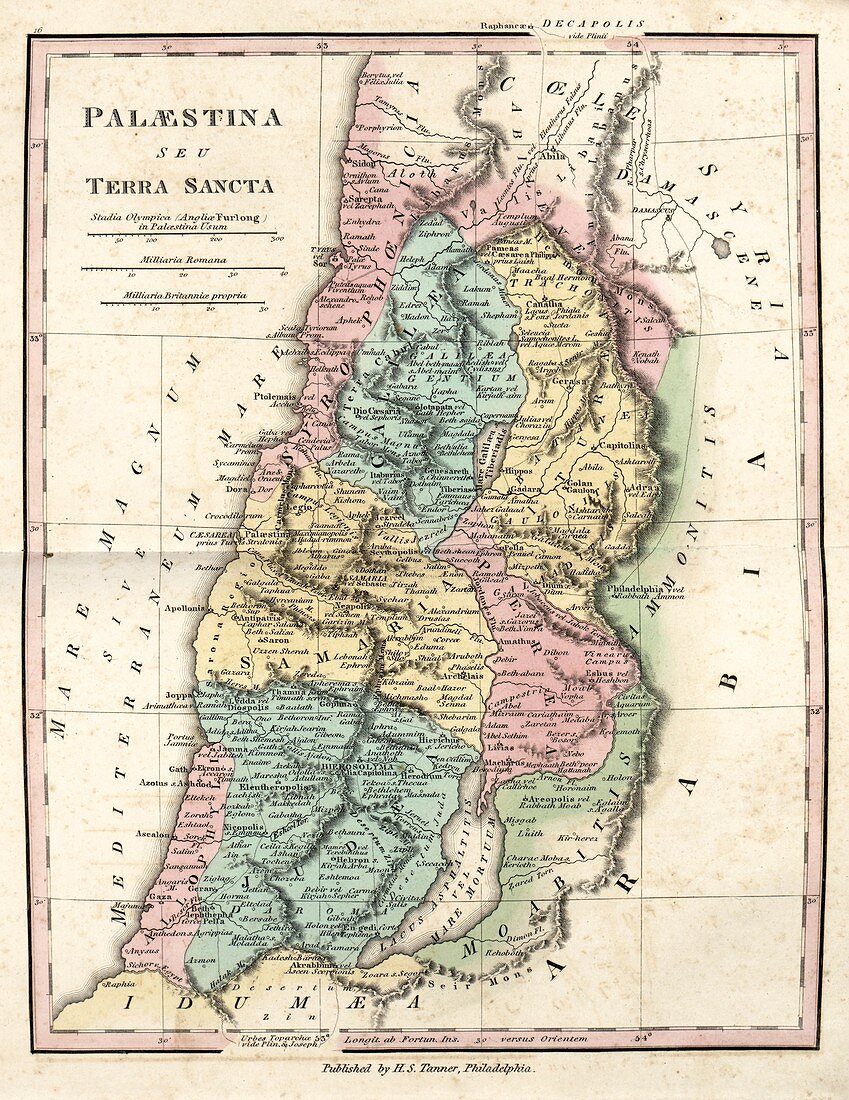
| Map of Ancient Palestine,19th century. This map of Palestine during the Roman Empire,also titled 'The Holy Land' in Latin,is divided by colour into regions such as Syrophoenicia (the Phoenicians),Galilee,Iturea,Samaria,Peraea,Allophyli (the Philistines),Judaea,and Moab (the Moabites). Also named are the territories of Idumea (which included Edom,bottom) and of the Ammonites,and Coele-Syria and Arabia. The Dead Sea and Sea of Galilee are both shown. The distance scales (upper left) are in Greek stadia,Roman miles,and British miles. Published in 'An Atlas of Ancient Geography' (1826) by US cartographer Henry Schenck Tanner (1786-1858) | |
| Lizenzart: | Lizenzpflichtig |
| Credit: | Science Photo Library / LIBRARY OF CONGRESS, Geography and Map Division |
| Bildgröße: | 3682 px × 4769 px |
| Modell-Rechte: | nicht erforderlich |
| Eigentums-Rechte: | nicht erforderlich |
| Restrictions: | - |
Preise für dieses Bild ab 15 €
Universitäten & Organisationen
(Informationsmaterial Digital, Informationsmaterial Print, Lehrmaterial Digital etc.)
ab 15 €
Redaktionell
(Bücher, Bücher: Sach- und Fachliteratur, Digitale Medien (redaktionell) etc.)
ab 30 €
Werbung
(Anzeigen, Aussenwerbung, Digitale Medien, Fernsehwerbung, Karten, Werbemittel, Zeitschriften etc.)
ab 55 €
Handelsprodukte
(bedruckte Textilie, Kalender, Postkarte, Grußkarte, Verpackung etc.)
ab 75 €
Pauschalpreise
Rechtepakete für die unbeschränkte Bildnutzung in Print oder Online
ab 495 €
Keywords
- 1800er Jahre,
- 19. Jahrhundert,
- Ammoniten,
- Antike,
- antike Welt,
- Arabien,
- Atlas,
- Blatt,
- Buch,
- Christentum,
- christlich,
- Galiläa,
- geografisch,
- Geographie,
- Geschichte,
- heiliges Land,
- historisch,
- Illustration,
- islam,
- islamisch,
- Israel,
- Israelisch,
- Israeliten,
- Judäa,
- Judentum,
- Jüdisch,
- Karte,
- Kartographie,
- klassisch,
- Kunstwerk,
- Latein,
- Mittlerer Osten,
- moab,
- Nahost,
- Niemand,
- Religion,
- religiös,
- römische Meilen,
- Römisches Reich,
- Syrien,
- Syrisch,
- Totes Meer,
- Veröffentlichung,
- Waage