Aral Sea reduction 1973-2000
Bildnummer 11745461
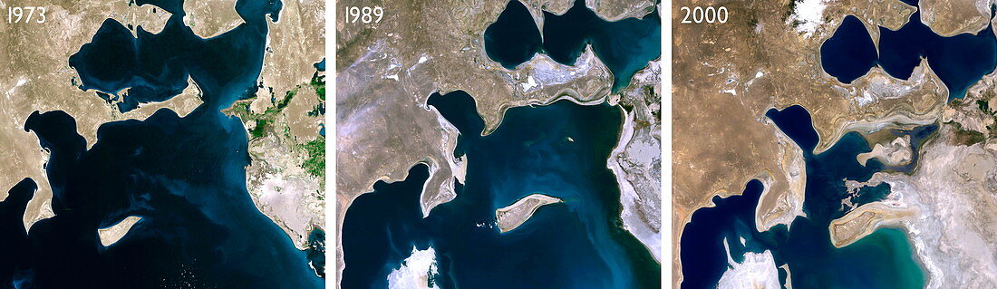
| Aral Sea reduction between 1973 and 2000,satellite images. North is at top. THe middle puicture dates from 1989. Since the 1960s the Aral Sea,on the borders of Uzbekistan (south west) and Kazakhstan (north east),has lost more than half of its volume. This is due to overuse of the feeder rivers (the Syr Darya and Amu Darya) in irrigation of cotton and paddy fields. The consequent receding waterline and increased salination has destroyed the region's fishing industry. Exposed areas of salt are blown by winds into the surrounding area,reducing crop yields | |
| Lizenzart: | Lizenzpflichtig |
| Credit: | Science Photo Library / Planetobserver |
| Bildgröße: | 3543 px × 1028 px |
| Modell-Rechte: | nicht erforderlich |
| Eigentums-Rechte: | nicht erforderlich |
| Restrictions: | - |
Preise für dieses Bild ab 15 €
Universitäten & Organisationen
(Informationsmaterial Digital, Informationsmaterial Print, Lehrmaterial Digital etc.)
ab 15 €
Redaktionell
(Bücher, Bücher: Sach- und Fachliteratur, Digitale Medien (redaktionell) etc.)
ab 30 €
Werbung
(Anzeigen, Aussenwerbung, Digitale Medien, Fernsehwerbung, Karten, Werbemittel, Zeitschriften etc.)
ab 55 €
Handelsprodukte
(bedruckte Textilie, Kalender, Postkarte, Grußkarte, Verpackung etc.)
ab 75 €
Pauschalpreise
Rechtepakete für die unbeschränkte Bildnutzung in Print oder Online
ab 495 €
Keywords
- 2000,
- Aralsee,
- Asien,
- Austrocknen,
- Drei,
- Dürre,
- Erdbeobachtung,
- geografisch,
- Geographie,
- Inland,
- Kasachstan,
- Meer,
- Panorama-,
- Salz,
- Salzig,
- Satellit,
- Satellitenbild,
- See,
- Trio,
- trocken,
- Trocknen,
- Umwelt,
- Weltall,
- Wüste