Alaskan coastline,satellite image
Bildnummer 11738865
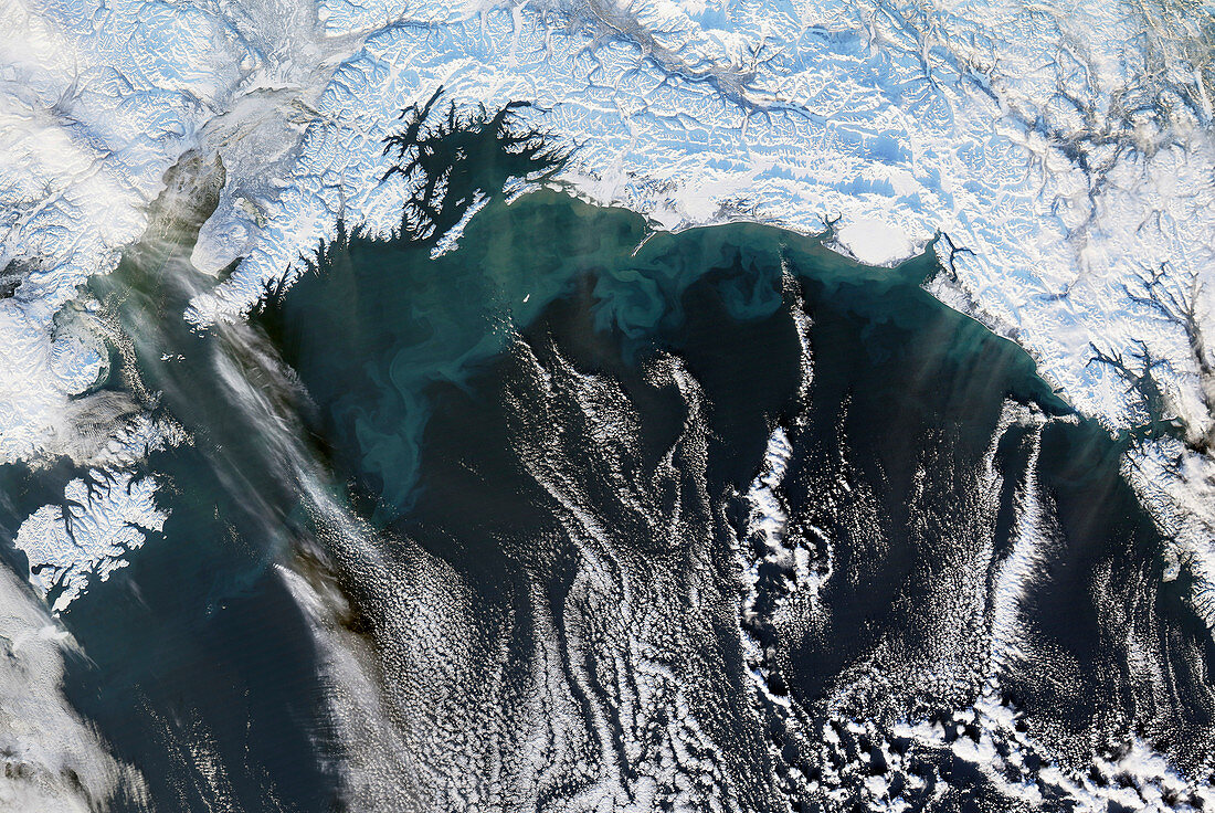
| Alaskan coastline,satellite image. North is at top. This is part of the southern coastline of Alaska,with the Gulf of Alaska (across bottom),and ice-covered land across top. Prince William Sound is the bay just left of upper centre. Wisps of clouds (white) are seen over the gulf. The turquoise swirls in the water are sediments ground up and carried down to the sea by glaciers. The area covered by this image is around 600 kilometres across. Image obtained on 7 January 2007,by the MODIS instrument on NASA's Aqua satellite | |
| Lizenzart: | Lizenzpflichtig |
| Credit: | Science Photo Library / NASA's Goddard Space Flight Center |
| Bildgröße: | 4648 px × 3112 px |
| Modell-Rechte: | nicht erforderlich |
| Eigentums-Rechte: | nicht erforderlich |
| Restrictions: | - |
Preise für dieses Bild ab 15 €
Universitäten & Organisationen
(Informationsmaterial Digital, Informationsmaterial Print, Lehrmaterial Digital etc.)
ab 15 €
Redaktionell
(Bücher, Bücher: Sach- und Fachliteratur, Digitale Medien (redaktionell) etc.)
ab 30 €
Werbung
(Anzeigen, Aussenwerbung, Digitale Medien, Fernsehwerbung, Karten, Werbemittel, Zeitschriften etc.)
ab 55 €
Handelsprodukte
(bedruckte Textilie, Kalender, Postkarte, Grußkarte, Verpackung etc.)
ab 75 €
Pauschalpreise
Rechtepakete für die unbeschränkte Bildnutzung in Print oder Online
ab 495 €
Keywords
- 1,
- 21. Jahrhundert,
- Alaska,
- Amerikanisch,
- aqua,
- Arktis,
- Berge,
- Bergkette,
- Bucht,
- Buchten,
- Eis,
- Erdbeobachtung,
- Fjord,
- Fjorde,
- geografisch,
- Geographie,
- Glaziologie,
- Gletscher,
- Golf von Alaska,
- Küste,
- Küsten-,
- Küstenlinie,
- Land,
- Meer,
- modis,
- Natur,
- Nordamerika,
- nordamerikanisch,
- Ozean,
- Pazifik,
- Satellit,
- Satellitenbild,
- Schnee,
- Sediment,
- Spektroradiometer,
- Umwelt,
- uns,
- USA,
- Vereinigte Staaten,
- Wasser,
- Weltall,
- Winter,
- Wolke,
- Wolken