Mexico City and Gulf of Mexico,1524
Bildnummer 11734806
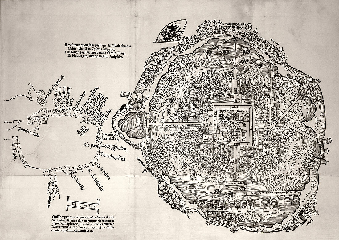
| Mexico City and Gulf of Mexico,1524. Mexico City-Tenochtitlan (right,West at top) was the capital of the Aztec Empire. This city was built on an island in the centre of Lake Texcoco in the Valley of Mexico. The city was connected to the surrounding areas by several causeways across the lake. The city was conquered by the Spanish (led by Cortes) in 1521. The map at left shows the coastline of the Gulf of Mexico,with North at bottom. Florida and Cuba are both shown at far left. This map was published three years after the conquest,as part of a letter by Cortes to the Hapsburg emperor Charles V (Holy Roman imperial double-headed eagle at upper centre) | |
| Lizenzart: | Lizenzpflichtig |
| Credit: | Science Photo Library / Library of Congress |
| Bildgröße: | 5249 px × 3719 px |
| Modell-Rechte: | nicht erforderlich |
| Eigentums-Rechte: | nicht erforderlich |
| Restrictions: | - |
Preise für dieses Bild ab 15 €
Universitäten & Organisationen
(Informationsmaterial Digital, Informationsmaterial Print, Lehrmaterial Digital etc.)
ab 15 €
Redaktionell
(Bücher, Bücher: Sach- und Fachliteratur, Digitale Medien (redaktionell) etc.)
ab 30 €
Werbung
(Anzeigen, Aussenwerbung, Digitale Medien, Fernsehwerbung, Karten, Werbemittel, Zeitschriften etc.)
ab 55 €
Handelsprodukte
(bedruckte Textilie, Kalender, Postkarte, Grußkarte, Verpackung etc.)
ab 75 €
Pauschalpreise
Rechtepakete für die unbeschränkte Bildnutzung in Print oder Online
ab 495 €
Keywords
- 1500er Jahre,
- 16. Jahrhundert,
- beschriftet,
- Einfarbig,
- Etikette,
- Etiketten,
- Florida,
- Fluss,
- Flüsse,
- geografisch,
- Geographie,
- Geschichte,
- Golf von Mexiko,
- Heiliges Römisches Reich,
- historisch,
- Illustration,
- Kaiser,
- Karte,
- Kartographie,
- Kolonial,
- König,
- Kuba,
- Kunstwerk,
- Latein,
- Mexikaner,
- Mexiko,
- Niemand,
- Nordamerika,
- nordamerikanisch,
- Rios,
- Schwarz und weiß,
- spanisch,
- spanische Eroberung,
- Stadt,
- Tabasco,
- Tempel,
- Tenochtitlan,
- Texcoco,
- Text