Halley's global magnetic chart,1700
Bildnummer 11703528
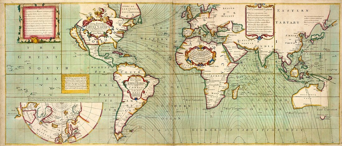
| Halley's global magnetic chart. Global sea chart showing the variation in magnetic compass readings as published in the year 1700 by the English astronomer,meteorologist and physicist Edmond Halley (1656-1742). In 1698 and 1699 Halley,most famous for his work on comets,was given command of a ship by King George III and told to record geographical variations in compass readings. Six inset boxes describe the map in English and Latin,with a map inset at lower left showing part of the Arctic region in polar projection. The dedication (in Africa) is to Prince George of Denmark,the husband of Queen Anne (reigned 1702 to 1707) | |
| Lizenzart: | Lizenzpflichtig |
| Credit: | Science Photo Library / NEW YORK PUBLIC LIBRARY / The Lionel Pincus and Princess Firyal Map Division / Stephen A. Schwarzman Building |
| Bildgröße: | 11538 px × 4941 px |
| Modell-Rechte: | nicht erforderlich |
| Eigentums-Rechte: | nicht erforderlich |
| Restrictions: | - |
Preise für dieses Bild ab 15 €
Universitäten & Organisationen
(Informationsmaterial Digital, Informationsmaterial Print, Lehrmaterial Digital etc.)
ab 15 €
Redaktionell
(Bücher, Bücher: Sach- und Fachliteratur, Digitale Medien (redaktionell) etc.)
ab 30 €
Werbung
(Anzeigen, Aussenwerbung, Digitale Medien, Fernsehwerbung, Karten, Werbemittel, Zeitschriften etc.)
ab 55 €
Handelsprodukte
(bedruckte Textilie, Kalender, Postkarte, Grußkarte, Verpackung etc.)
ab 75 €
Pauschalpreise
Rechtepakete für die unbeschränkte Bildnutzung in Print oder Online
ab 495 €
Keywords
- 1700er Jahre,
- 18. Jahrhundert,
- Diagramm,
- Englisch,
- Erde,
- Forschung,
- geografisch,
- Geographie,
- Geschichte,
- historisch,
- Illustration,
- Karte,
- Karten,
- Kartographie,
- Kunstwerk,
- Latein,
- Linien,
- Marine,
- Maritim,
- Meer,
- Meereskunde,
- Meteorologie,
- meteorologisch,
- Navigation,
- Niemand,
- Ozean,
- Patron,
- Planet,
- planetarisch,
- Schreiben,
- Variation,
- weltweit,
- Widmung