British Isles storm and ash plume,2011
Bildnummer 11603663
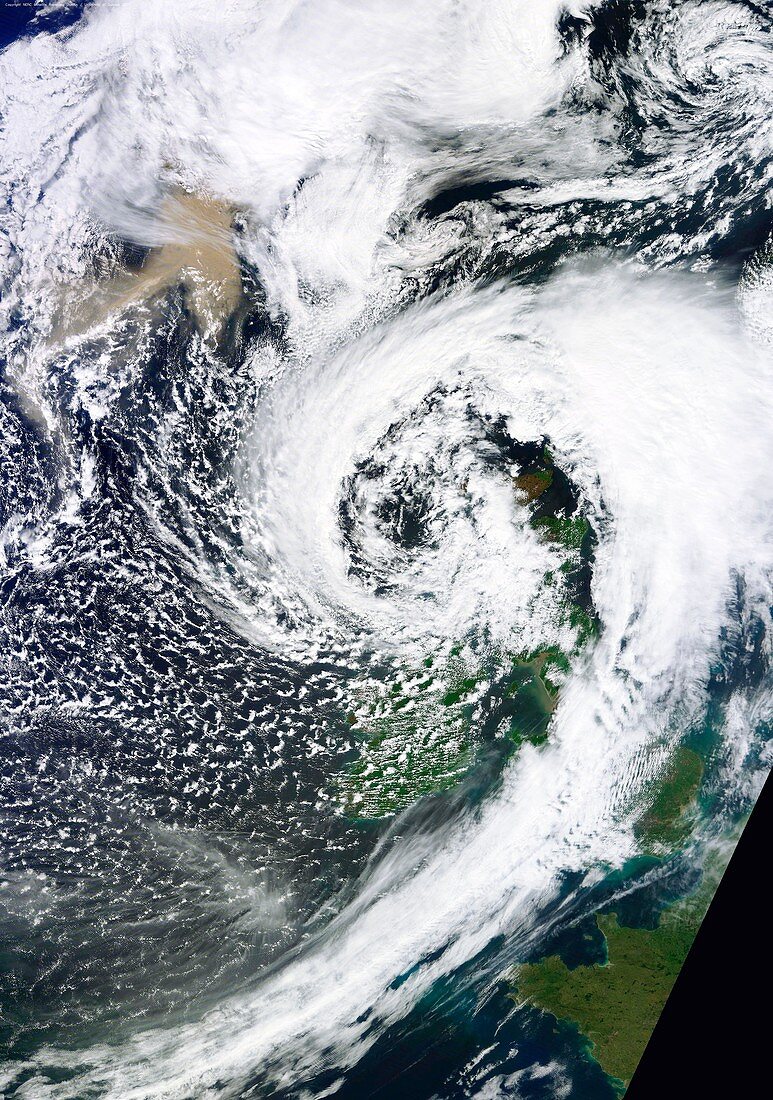
| British Isles storm and ash plume,May 2011,satellite image. This low-pressure storm system is seen as a spiral cloud formation,with Ireland just below centre and the UK mainland at right. Part of France is at lower right. At upper left,the brown patch is an ash plume being blown southwards from the eruption of the Grimsvotn volcano in Iceland. Like the Eyjafjallajokull eruption of 2010,this one is disrupting UK airspace,though the ash is of a different sort and the disruption is expected to be less severe. The eruption started on 21 May 2011,and this image was obtained by the MODIS sensor on a NASA satellite on 23 May 2011 | |
| Lizenzart: | Lizenzpflichtig |
| Credit: | Science Photo Library / University of Dundee |
| Bildgröße: | 3503 px × 4984 px |
| Modell-Rechte: | nicht erforderlich |
| Eigentums-Rechte: | nicht erforderlich |
| Restrictions: | - |
Preise für dieses Bild ab 15 €
Universitäten & Organisationen
(Informationsmaterial Digital, Informationsmaterial Print, Lehrmaterial Digital etc.)
ab 15 €
Redaktionell
(Bücher, Bücher: Sach- und Fachliteratur, Digitale Medien (redaktionell) etc.)
ab 30 €
Werbung
(Anzeigen, Aussenwerbung, Digitale Medien, Fernsehwerbung, Karten, Werbemittel, Zeitschriften etc.)
ab 55 €
Handelsprodukte
(bedruckte Textilie, Kalender, Postkarte, Grußkarte, Verpackung etc.)
ab 75 €
Pauschalpreise
Rechtepakete für die unbeschränkte Bildnutzung in Print oder Online
ab 495 €
Keywords
- 2011,
- 21. Jahrhundert,
- Asche,
- Blütezeit,
- britisch,
- Erdbeobachtung,
- Erdkunde,
- Eruption,
- Europa,
- europäisch,
- Flugzeug,
- Flugzeuge,
- Gefahr,
- gefährlich,
- Geologie,
- geologisch,
- Geschlossen,
- Großbritannien,
- Hagedorn,
- Island,
- Isländisch,
- Luftfahrt,
- Luftraum,
- modis,
- Natur,
- Plume,
- Risiko,
- Satellit,
- Satellitenbild,
- Schottland,
- Sturm,
- Tephra,
- Transport,
- Vatnajokull,
- Vereinigtes Königreich,
- Vulkan,
- Vulkanausbruch,
- vulkanisch,
- Vulkanologie,
- Weltall,
- Wolke,
- Wolken,
- Wolkig