World land topography
Bildnummer 11575692
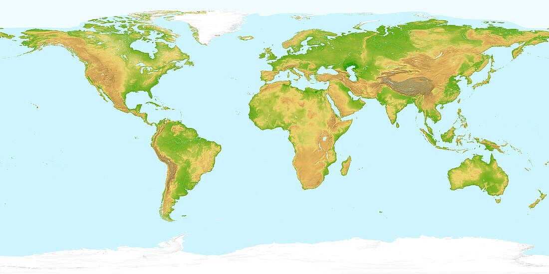
| World land topography,satellite image. Height is colour-coded from green at sea level,through yellow to grey-brown for the highest mountains. Areas of permanent snow or ice cover are shown in white,as is typical summer sea ice extent in the Arctic Ocean. The land satellite imagery is from the AVHRR sensor on the NOAA Polar Orbiter weather satellites. Land topography data was obtained with radar measurements from the Space Shuttle program. Coastlines,lakes,rivers and ice cover are overlaid from a digital map | |
| Lizenzart: | Lizenzpflichtig |
| Credit: | Science Photo Library / Planetary Visions |
| Bildgröße: | 5929 px × 2965 px |
| Modell-Rechte: | nicht erforderlich |
| Eigentums-Rechte: | nicht erforderlich |
| Restrictions: | - |
Preise für dieses Bild ab 15 €
Universitäten & Organisationen
(Informationsmaterial Digital, Informationsmaterial Print, Lehrmaterial Digital etc.)
ab 15 €
Redaktionell
(Bücher, Bücher: Sach- und Fachliteratur, Digitale Medien (redaktionell) etc.)
ab 30 €
Werbung
(Anzeigen, Aussenwerbung, Digitale Medien, Fernsehwerbung, Karten, Werbemittel, Zeitschriften etc.)
ab 55 €
Handelsprodukte
(bedruckte Textilie, Kalender, Postkarte, Grußkarte, Verpackung etc.)
ab 75 €
Pauschalpreise
Rechtepakete für die unbeschränkte Bildnutzung in Print oder Online
ab 495 €
Keywords
- 21. Jahrhundert,
- Afrika,
- Anden,
- Antarktis,
- Arktis,
- Asien,
- Australien,
- AVHRR,
- Berg,
- Berge,
- Erdbeobachtung,
- Erde,
- Erdkunde,
- Eurasien,
- Europa,
- Flüsse,
- geografisch,
- Geographie,
- Geologie,
- geologisch,
- Himalaya,
- Insel,
- Inseln,
- Kontinent,
- Kontinente,
- Land,
- Meer,
- NOAA,
- Nordamerika,
- Ozean,
- Ozeane,
- Planet,
- planetarisch,
- Region,
- Reichweite,
- Rockies,
- Rocky Mountains,
- Satellit,
- Satellitenbild,
- Seen,
- Space Shuttle,
- SRTM,
- Südamerika,
- topografisch,
- Topographie,
- Wasser,
- Welt,
- Weltall,
- weltweit