Hebes Chasma,Mars,satellite image
Bildnummer 11570144
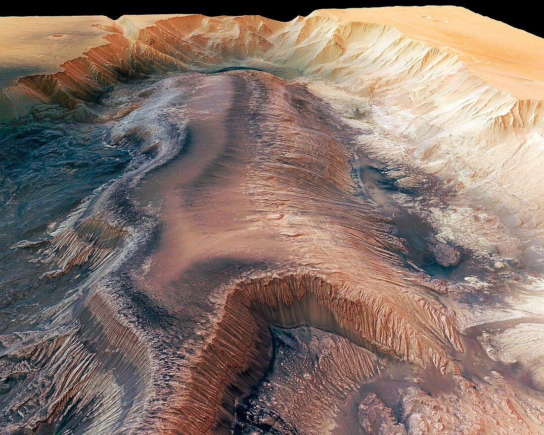
| Hebes Chasma,Mars,satellite image. North is at right. This is a perspective stereo-colour image of Hebes Chasma,an enclosed trough formed by volcanic activity,descending to depths of 8 kilometres. It is some 300 kilometres long,and in its centre is this flat-topped tableland,with rock layers revealed by erosion. It is thought that groundwater once flowed through this canyon,and the tableland also has multiple erosion gullies on its sides. The image data is from the High Resolution Stereo Camera (HRSC) on board the European Space Agency's (ESA) Mars Express Orbiter | |
| Lizenzart: | Lizenzpflichtig |
| Credit: | Science Photo Library / Neukum, G. / FU Berlin / ESA / DLR |
| Bildgröße: | 4707 px × 3765 px |
| Modell-Rechte: | nicht erforderlich |
| Eigentums-Rechte: | nicht erforderlich |
| Restrictions: |
|
Preise für dieses Bild ab 15 €
Universitäten & Organisationen
(Informationsmaterial Digital, Informationsmaterial Print, Lehrmaterial Digital etc.)
ab 15 €
Redaktionell
(Bücher, Bücher: Sach- und Fachliteratur, Digitale Medien (redaktionell) etc.)
ab 30 €
Werbung
(Anzeigen, Aussenwerbung, Digitale Medien, Fernsehwerbung, Karten, Werbemittel, Zeitschriften etc.)
ab 55 €
Handelsprodukte
(bedruckte Textilie, Kalender, Postkarte, Grußkarte, Verpackung etc.)
ab 75 €
Pauschalpreise
Rechtepakete für die unbeschränkte Bildnutzung in Print oder Online
ab 495 €
Keywords
- 21. Jahrhundert,
- Astronomie,
- astronomisch,
- bewegliche Flüssigkeit,
- erodiert,
- Erosion,
- Fließen,
- Fluid,
- geografisch,
- Geographie,
- Geschnitzt,
- Hebes Chasma,
- hochauflösende Stereokamera,
- HRSC,
- Klippe,
- Klippen,
- Mars,
- mars Express,
- Mesa,
- Orange,
- perspektivische Ansicht,
- Planet,
- Planetenwissenschaft,
- Plateau,
- Satellit,
- Satellitenbild,
- Schlucht,
- Schluchten,
- Sonnensystem,
- Tal,
- Täler,
- Tief,
- vom Mars,
- Wasser,
- Wasserrinne,
- Weltall