Puebla region,Mexico,satellite image
Bildnummer 11551784
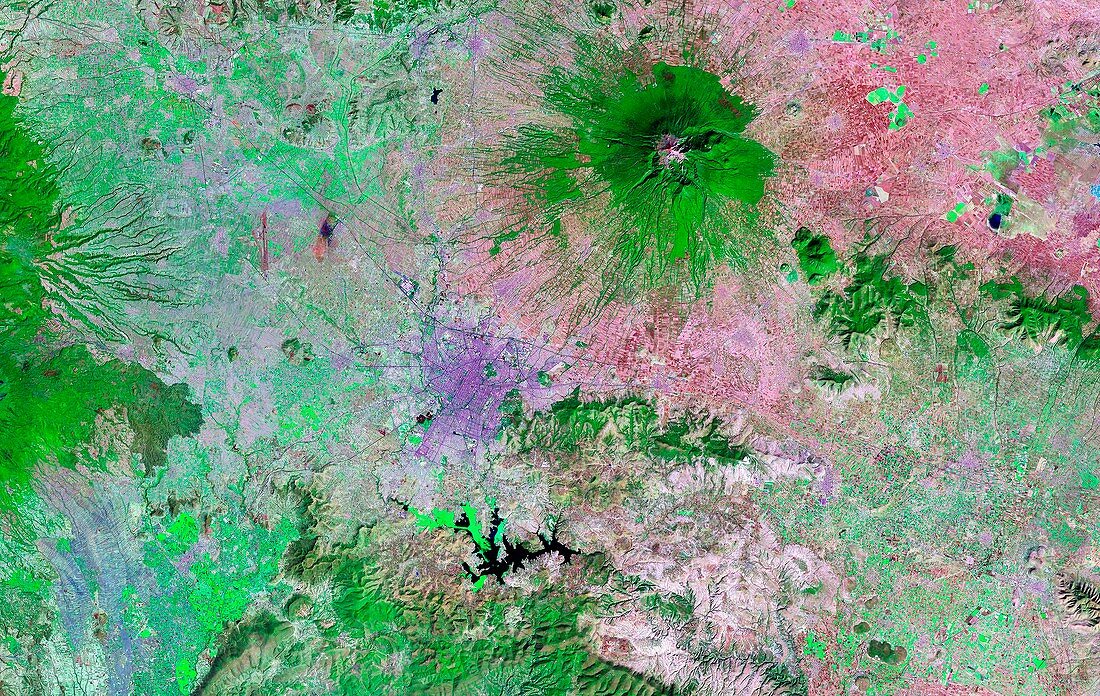
| Puebla region,Mexico,infrared satellite image. North is at top. Vegetation is green or red. The city of Puebla is at centre (purple area),with the Malinche volcano (green) at upper right. Numerous fields are seen in the surrounding valley. To the south of the city is the Valsequillo Reservoir (black). In 2003,a large collection of prehistoric footprints (animal and human) were discovered in the Cerro Toluquilla quarry on the north shore of the reservoir. The footprints had been preserved in a layer of volcanic ash. In 2005,they were dated to about 40,000 years ago,challenging previously accepted theories about when the Americas were colonised. The area shown here is around 100 kilometres across. Image obtained by a Landsat satellite | |
| Lizenzart: | Lizenzpflichtig |
| Credit: | Science Photo Library / NASA |
| Bildgröße: | 6225 px × 3938 px |
| Modell-Rechte: | nicht erforderlich |
| Eigentums-Rechte: | nicht erforderlich |
| Restrictions: | - |
Preise für dieses Bild ab 15 €
Universitäten & Organisationen
(Informationsmaterial Digital, Informationsmaterial Print, Lehrmaterial Digital etc.)
ab 15 €
Redaktionell
(Bücher, Bücher: Sach- und Fachliteratur, Digitale Medien (redaktionell) etc.)
ab 30 €
Werbung
(Anzeigen, Aussenwerbung, Digitale Medien, Fernsehwerbung, Karten, Werbemittel, Zeitschriften etc.)
ab 55 €
Handelsprodukte
(bedruckte Textilie, Kalender, Postkarte, Grußkarte, Verpackung etc.)
ab 75 €
Pauschalpreise
Rechtepakete für die unbeschränkte Bildnutzung in Print oder Online
ab 495 €
Keywords
- 1900er Jahre,
- 20. Jahrhundert,
- älteste,
- Anthropologie,
- anthropologisch,
- Archäologie,
- archäologisch,
- Bauernhof,
- Berg,
- cerro Toluquilla,
- Entdeckung,
- Feld,
- Felder,
- Fossil,
- Fossilien,
- frühe Siedler,
- Fußabdruck,
- Fußabdrücke,
- geografisch,
- Geographie,
- infrarot,
- Konserviert,
- ländlich,
- Landschaft,
- Lateinamerika,
- Mensch,
- Menschen,
- menschliche Migration,
- Mexikaner,
- Mexiko,
- neolithisch,
- Nordamerika,
- nordamerikanisch,
- Paläontologie,
- paläontologisch,
- Person,
- prähistorisch,
- prähistorischer Mensch,
- Puebla,
- Reservoir,
- Satellit,
- Satellitenbild,
- Stadt,
- städtisch,
- Steinzeit,
- Tal,
- Tier,
- Valsequillo-Becken,
- Vorgeschichte,
- Vulkan,
- vulkanisch,
- Weltall