Arctic sea ice maximum, February 2021
Bildnummer 13601184
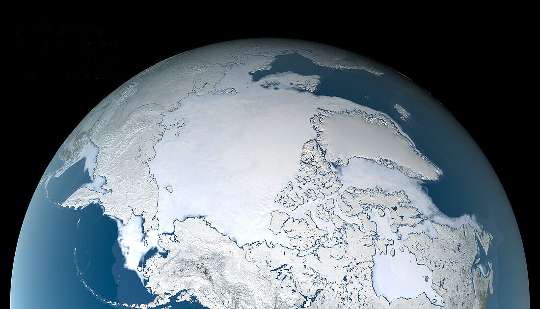
| Arctic sea ice maximum, 25th February 2021, satellite image. The Arctic sea ice (white) reaches a maximum around late February-early March, at the end of the Arctic winter. This maximum extent for 2021 covered 14.88 million square kilometres. This is the third earliest maximum extent. The Arctic sea ice maximum extent has dropped by an average of 2.8 percent per decade since 1979. The sea ice data for this image is from the AMSR2 (Advanced Microwave Scanning Radiometer 2) sensor on the Japanese Shizuku satellite. | |
| Lizenzart: | Lizenzpflichtig |
| Credit: | Science Photo Library / / JAXA / GSFC / NASA's Scientific Visualization Studio |
| Bildgröße: | 3969 px × 2268 px |
| Modell-Rechte: | nicht erforderlich |
| Eigentums-Rechte: | nicht erforderlich |
| Restrictions: | - |
Preise für dieses Bild ab 15 €
Universitäten & Organisationen
(Informationsmaterial Digital, Informationsmaterial Print, Lehrmaterial Digital etc.)
ab 15 €
Redaktionell
(Bücher, Bücher: Sach- und Fachliteratur, Digitale Medien (redaktionell) etc.)
ab 30 €
Werbung
(Anzeigen, Aussenwerbung, Digitale Medien, Fernsehwerbung, Karten, Werbemittel, Zeitschriften etc.)
ab 55 €
Handelsprodukte
(bedruckte Textilie, Kalender, Postkarte, Grußkarte, Verpackung etc.)
ab 75 €
Pauschalpreise
Rechtepakete für die unbeschränkte Bildnutzung in Print oder Online
ab 495 €
Keywords
- 21. Jahrhundert,
- Alaska,
- Arktis,
- Arktischer Ozean,
- eisig,
- Erdbeobachtung,
- Erde,
- Gefroren,
- gefrorenes Wasser,
- geografisch,
- Geographie,
- Glaziologie,
- Globale Erwärmung,
- Kalt,
- Karte,
- Klimatologie,
- klimatologisch,
- Klimawandel,
- Max,
- maximal,
- Meereis,
- Mikrowelle,
- Modell-,
- nordamerikanisch,
- Planet,
- Raum,
- Russisch,
- Russland,
- Satellit,
- Satellitenbild,
- Sibirien,
- Sibirisch,
- Umwelt,
- Weltall,
- Winter