Map, Johnstown flood, Pennsylvania, 1889
Bildnummer 13501832
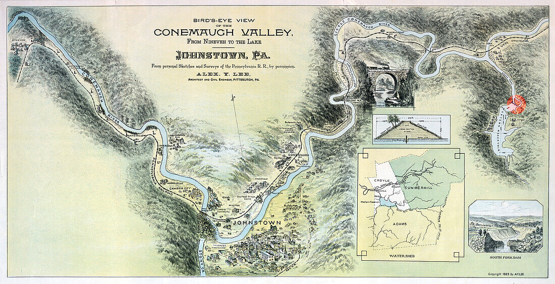
| Map of the Johnstown vicinity showing the route of the waters of the Johnstown Flood of 31 May 1889 and the devastated areas resulting from them. The Johnstown Flood (or Great Flood of 1889 as it became known locally) occurred on May 31, 1889. It was the result of the catastrophic failure of the South Fork Dam (red dot on this map), situated on the Little Conemaugh River 14 miles upstream of the town of Johnstown, Pennsylvania, made worse by several days of extremely heavy rainfall. The dam's failure unleashed a torrent of 20 million tons of water from the reservoir known as Lake Conemaugh. The flood killed 2, 209 people and caused 17 million US dollars in damages. It was the first major disaster relief effort handled by the new American Red Cross, led by Clara Barton. Support for victims came from all over the United States and 18 foreign countries. After the flood, survivors suffered a series of legal defeats in their attempts to recover damages from the dam's owners, prompting the development in American law changing a fault-based regime to strict liability. | |
| Lizenzart: | Lizenzpflichtig |
| Credit: | Science Photo Library / Science Source |
| Bildgröße: | 7200 px × 3680 px |
| Modell-Rechte: | nicht erforderlich |
| Eigentums-Rechte: | nicht erforderlich |
| Restrictions: | - |
Preise für dieses Bild ab 15 €
Universitäten & Organisationen
(Informationsmaterial Digital, Informationsmaterial Print, Lehrmaterial Digital etc.)
ab 15 €
Redaktionell
(Bücher, Bücher: Sach- und Fachliteratur, Digitale Medien (redaktionell) etc.)
ab 30 €
Werbung
(Anzeigen, Aussenwerbung, Digitale Medien, Fernsehwerbung, Karten, Werbemittel, Zeitschriften etc.)
ab 55 €
Handelsprodukte
(bedruckte Textilie, Kalender, Postkarte, Grußkarte, Verpackung etc.)
ab 75 €
Pauschalpreise
Rechtepakete für die unbeschränkte Bildnutzung in Print oder Online
ab 495 €
Keywords
- 19. Jahrhundert,
- Amerika,
- atmosphärisch,
- berühmt,
- beschriftet,
- brutal,
- Damm,
- eingefärbt,
- extrem,
- farbig,
- Fluss,
- Flut,
- Flutschaden,
- Folge,
- gefärbt,
- Geschichte,
- Grafik,
- Karte,
- Katastrophe,
- Meteorologie,
- Naturkatastrophe,
- Naturphänomen,
- Niemand,
- Pennsylvania,
- Phänomene,
- Schaden,
- Sturm,
- überflutet,
- Überschwemmung,
- USA,
- Veranstaltung,
- verbessern,
- verbessert,
- Wetter