Flooding in Western Europe, July 2021, satellite image
Bildnummer 13444540
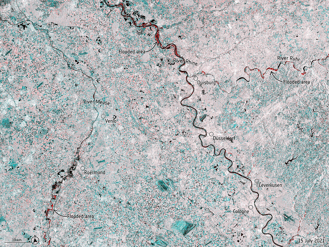
| Radar satellite image of flooding (red) along the River Meuse (left) in the Netherlands and Belgium, and the River Rhine (centre right) and River Ruhr (top right) in Germany, on the 15th July 2021. This flooding resulted from more than a month's worth of rain falling in 24 hours. The flooding caused massive damage to buildings and infrastructure and the loss of at least 180 lives. Satellite data from the Copernicus Sentinel-1 satellite. | |
| Lizenzart: | Lizenzpflichtig |
| Credit: | Science Photo Library / EUROPEAN SPACE AGENCY / Copernicus Sentinel data (2021) |
| Bildgröße: | 6746 px × 5060 px |
| Modell-Rechte: | nicht erforderlich |
| Eigentums-Rechte: | nicht erforderlich |
| Restrictions: |
|
Preise für dieses Bild ab 15 €
Universitäten & Organisationen
(Informationsmaterial Digital, Informationsmaterial Print, Lehrmaterial Digital etc.)
ab 15 €
Redaktionell
(Bücher, Bücher: Sach- und Fachliteratur, Digitale Medien (redaktionell) etc.)
ab 30 €
Werbung
(Anzeigen, Aussenwerbung, Digitale Medien, Fernsehwerbung, Karten, Werbemittel, Zeitschriften etc.)
ab 55 €
Handelsprodukte
(bedruckte Textilie, Kalender, Postkarte, Grußkarte, Verpackung etc.)
ab 75 €
Pauschalpreise
Rechtepakete für die unbeschränkte Bildnutzung in Print oder Online
ab 495 €
Keywords
- 2000er Jahre,
- 21. Jahrhundert,
- Belgien,
- beschriftet,
- Deutschland,
- Düsseldorf,
- Etikette,
- Etiketten,
- europäisch,
- extremes Wetter,
- Fluss,
- Globale Erwärmung,
- Holland,
- Karte,
- Katastrophe,
- Klimawandel,
- Köln,
- Meteorologie,
- meteorologisch,
- Naturkatastrophe,
- Niederlande,
- Niederländisch,
- Niemand,
- Nordrhein-Westfalen,
- Regen,
- Rheinland-Pfalz,
- Satellitenbild,
- Sturm,
- Text,
- überflutet,
- Weltall,
- Westeuropa