Sonar, illustration
Bildnummer 13377693
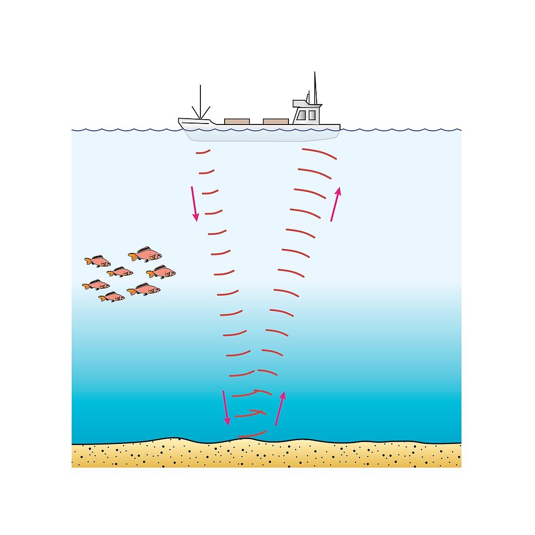
| Illustration of a ship using sonar beams (sound waves) to locate the ocean floor. The sonar beams reflect off the ocean floor and are collected by a receiver. The time taken for the beam to return allows the depth of water to be calculated. This can be used to gauge water depth and to map the ocean floor in the study plate tectonics, model ocean currents, and map wildlife habitats, amongst other applications. | |
| Lizenzart: | Lizenzpflichtig |
| Credit: | Science Photo Library |
| Bildgröße: | 4181 px × 4181 px |
| Modell-Rechte: | nicht erforderlich |
| Eigentums-Rechte: | nicht erforderlich |
| Restrictions: | - |
Preise für dieses Bild ab 15 €
Universitäten & Organisationen
(Informationsmaterial Digital, Informationsmaterial Print, Lehrmaterial Digital etc.)
ab 15 €
Redaktionell
(Bücher, Bücher: Sach- und Fachliteratur, Digitale Medien (redaktionell) etc.)
ab 30 €
Werbung
(Anzeigen, Aussenwerbung, Digitale Medien, Fernsehwerbung, Karten, Werbemittel, Zeitschriften etc.)
ab 55 €
Handelsprodukte
(bedruckte Textilie, Kalender, Postkarte, Grußkarte, Verpackung etc.)
ab 75 €
Pauschalpreise
Rechtepakete für die unbeschränkte Bildnutzung in Print oder Online
ab 495 €
Keywords
- Akustik,
- akustisch,
- ausgeschnitten,
- Ausrüstung,
- Ausschnitte,
- Balken,
- Bathymetrie,
- Bildung,
- Bildungs-,
- Boot,
- Demonstration,
- Diagramm,
- Energie,
- Fahrzeug,
- fegen,
- Fisch,
- forschend,
- Forschung,
- gcse,
- Gefäß,
- geografisch,
- Geographie,
- Gerät,
- Illustration,
- Info-Grafiken,
- Infografik,
- Infografiken,
- Informationsgrafiken,
- Ingenieurwesen,
- Karte,
- Klang,
- Kompression,
- Konzept,
- Konzepte,
- konzeptionell,
- Kunstwerk,
- mechanisch,
- Meer,
- Meeresboden,
- Meereskunde,
- Messung,
- Naturwissenschaft in der Schule,
- Niemand,
- Ort,
- Physik,
- physisch,
- Reise,
- Reisen,
- Schiff,
- Strahl,
- Technologie,
- technologisch,
- Terrain,
- topografisch,
- topographisch,
- weißer Hintergrund,
- Welle,
- Wellenlänge,
- Wissenschaftspädagogik,
- Zeichnung