Antarctic ozone hole, September 2020
Bildnummer 13367729
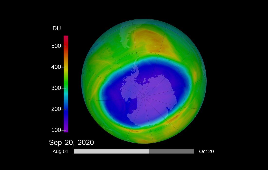
| Satellite image of the extent of the ozone hole (purple and blue) over Antarctica on 20th September 2020. Ozone layer thicknesses are colour coded from purple (lowest) through blue, green and yellow to red (highest). The ozone hole reached its annual maximum on 2nd October 2020, covering an area of around 25 million square kilometres. The 2020 hole was one of the deepest for years, but was comparable in size to the peaks of 2018 and 2015. The amount of ozone depleting substances have decreased from peak levels in 2000. | |
| Lizenzart: | Lizenzpflichtig |
| Credit: | Science Photo Library / NASA's Goddard Space Flight Center |
| Bildgröße: | 4000 px × 2548 px |
| Modell-Rechte: | nicht erforderlich |
| Eigentums-Rechte: | nicht erforderlich |
| Restrictions: | - |
Preise für dieses Bild ab 15 €
Universitäten & Organisationen
(Informationsmaterial Digital, Informationsmaterial Print, Lehrmaterial Digital etc.)
ab 15 €
Redaktionell
(Bücher, Bücher: Sach- und Fachliteratur, Digitale Medien (redaktionell) etc.)
ab 30 €
Werbung
(Anzeigen, Aussenwerbung, Digitale Medien, Fernsehwerbung, Karten, Werbemittel, Zeitschriften etc.)
ab 55 €
Handelsprodukte
(bedruckte Textilie, Kalender, Postkarte, Grußkarte, Verpackung etc.)
ab 75 €
Pauschalpreise
Rechtepakete für die unbeschränkte Bildnutzung in Print oder Online
ab 495 €
Keywords
- 2000er Jahre,
- 21. Jahrhundert,
- Antarktis,
- Atmosphäre,
- Beschädigt,
- chemisch,
- Erdbeobachtung,
- Erde,
- Forschung,
- Geowissenschaften,
- Globus,
- Messung,
- Montreal-Protokoll,
- Niemand,
- Planet,
- Planetenwissenschaft,
- polar,
- Satellitenbild,
- Schaden,
- Schlüssel,
- schwarzer Hintergrund,
- Süden,
- südlichen Hemisphäre,
- Südpol,
- Umwelt,
- Umweltwissenschaften,
- verschmutzt,
- Verschmutzung,
- Weltall