IBM research on Nazca Lines
Bildnummer 12992053
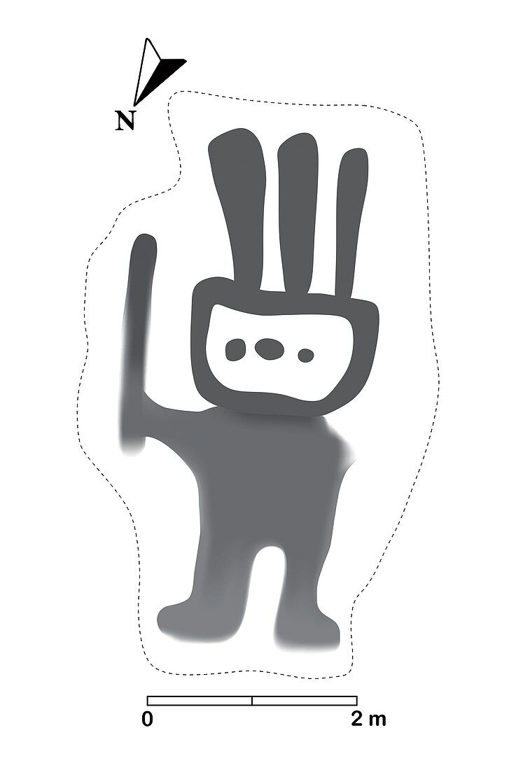
| IBM research on Nazca Lines. Drawing of an example of Nazca Lines, uncovered by IBM research using artificial intelligence (AI) and geospatial data. Nazca Lines are ancient geoglyphs (landscape drawings) in the Nazca Desert of southern Peru. These geoglyphs cover huge areas and can only be properly seen from the air. For an aerial photograph of this geoglyph, see image C048/5622. The Nazca Lines were made by removing the dark surface stone to reveal a lighter stone layer underneath. They are thought to have been made by the Nazca, a native South American people, between around 400 and 650 AD. Theories about the lines have ranged from uses in astronomy (for seasonal agriculture) to ceremonial uses in religion. This example was discovered using IBM Watson Machine Learning Accelerator on IBM Power Systems. Image published in November 2019. | |
| Lizenzart: | Lizenzpflichtig |
| Credit: | Science Photo Library / IBM Research |
| Bildgröße: | 2651 px × 3957 px |
| Modell-Rechte: | nicht erforderlich |
| Eigentums-Rechte: | nicht erforderlich |
| Restrictions: | - |
Preise für dieses Bild ab 15 €
Universitäten & Organisationen
(Informationsmaterial Digital, Informationsmaterial Print, Lehrmaterial Digital etc.)
ab 15 €
Redaktionell
(Bücher, Bücher: Sach- und Fachliteratur, Digitale Medien (redaktionell) etc.)
ab 30 €
Werbung
(Anzeigen, Aussenwerbung, Digitale Medien, Fernsehwerbung, Karten, Werbemittel, Zeitschriften etc.)
ab 55 €
Handelsprodukte
(bedruckte Textilie, Kalender, Postkarte, Grußkarte, Verpackung etc.)
ab 75 €
Pauschalpreise
Rechtepakete für die unbeschränkte Bildnutzung in Print oder Online
ab 495 €
Keywords
- 2019,
- 21. Jahrhundert,
- AI,
- Alter,
- Anthropologie,
- anthropologisch,
- Antike,
- Archäologie,
- archäologisch,
- Carving,
- Computerwesen,
- Erdbeobachtung,
- geografisch,
- Geographie,
- Geologie,
- geologisch,
- Geschichte,
- Geschnitzt,
- herabsehend,
- historisch,
- Illustration,
- künstliche Intelligenz,
- Kunstwerk,
- Lateinamerika,
- Linie,
- Nazca-Linien,
- Niemand,
- Peru,
- Peruanisch,
- Südamerika,
- Südamerikanisch,
- Tourismus,
- Touristenattraktion,
- Unesco,
- Von Oben,
- Weltkulturerbe,
- Zeichnungen