Permafrost map for Earth's northern hemisphere
Bildnummer 12991473
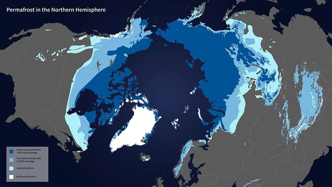
| Permafrost map for Earth's northern hemisphere. Permafrost is defined as soil, rock, and any other subsurface Earth material that exists at or below zero degrees Celsius for two or more consecutive years. The colour-coding (key at bottom left) shows areas that are continuous or discontinuous or sporadic permafrost, as well as isolated areas and ice sheets and glaciers. This updated map from 2012 is based on an earlier version from 1997 by the International Permafrost Association. The updating used data from the Soil Moisture Active Passive (SMAP) mission, NASA's first Earth-observing satellite mission designed to collect continuous global observations of surface soil moisture conditions. This research is used to help track trends caused by climate change and global warming. Image published in 2015. | |
| Lizenzart: | Lizenzpflichtig |
| Credit: | Science Photo Library / NASA's Scientific Visualization Studio / NASA |
| Bildgröße: | 5634 px × 3169 px |
| Modell-Rechte: | nicht erforderlich |
| Eigentums-Rechte: | nicht erforderlich |
| Restrictions: | - |
Preise für dieses Bild ab 15 €
Universitäten & Organisationen
(Informationsmaterial Digital, Informationsmaterial Print, Lehrmaterial Digital etc.)
ab 15 €
Redaktionell
(Bücher, Bücher: Sach- und Fachliteratur, Digitale Medien (redaktionell) etc.)
ab 30 €
Werbung
(Anzeigen, Aussenwerbung, Digitale Medien, Fernsehwerbung, Karten, Werbemittel, Zeitschriften etc.)
ab 55 €
Handelsprodukte
(bedruckte Textilie, Kalender, Postkarte, Grußkarte, Verpackung etc.)
ab 75 €
Pauschalpreise
Rechtepakete für die unbeschränkte Bildnutzung in Print oder Online
ab 495 €
Keywords
- 2012,
- 21. Jahrhundert,
- Arktis,
- eisig,
- Erdbeobachtung,
- farbcodiert,
- Gefroren,
- geografisch,
- Geowissenschaften,
- Glaziologie,
- Globale Erwärmung,
- Grafik,
- isoliert,
- Kalt,
- Kanada,
- Kanadisch,
- Karte,
- Klimatologie,
- klimatologisch,
- Klimawandel,
- Modell-,
- Niemand,
- nördliche Hemisphäre,
- polar,
- Russisch,
- Russland,
- Satellit,
- Skandinavien,
- Weltall