Age distribution of Arctic sea ice, 2019
Bildnummer 12991469
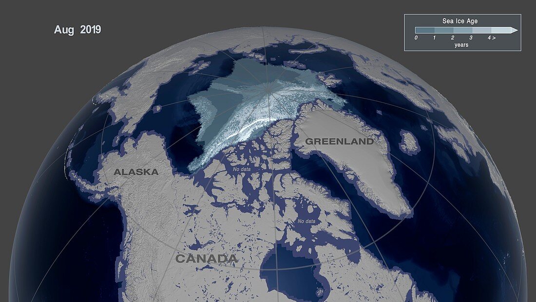
| Age distribution of Arctic sea ice, 2019. Map based on satellite data showing sea ice in the Arctic in August near its minimum level for 2019. The ice is shaded according to its age, which ranges from over four years (white) to less than a year (darker grey). Ice that is present for more than a year is known as multi-year ice or perennial ice. It starts off around 2 metres thick, but can reach a thickness of over nine metres. The decline in perennial ice in the Arctic is an indication of climate change. A key to the shading and the distribution by age is at top right. This data was obtained using a variety of satellite sensors, and is provided by the National Snow and Ice Data Center (NSIDC). For a map displaying the data for 1987, see image C048/5024. | |
| Lizenzart: | Lizenzpflichtig |
| Credit: | Science Photo Library / NASA's Scientific Visualization Studio / NASA |
| Bildgröße: | 4323 px × 2432 px |
| Modell-Rechte: | nicht erforderlich |
| Eigentums-Rechte: | nicht erforderlich |
| Restrictions: | - |
Preise für dieses Bild ab 15 €
Universitäten & Organisationen
(Informationsmaterial Digital, Informationsmaterial Print, Lehrmaterial Digital etc.)
ab 15 €
Redaktionell
(Bücher, Bücher: Sach- und Fachliteratur, Digitale Medien (redaktionell) etc.)
ab 30 €
Werbung
(Anzeigen, Aussenwerbung, Digitale Medien, Fernsehwerbung, Karten, Werbemittel, Zeitschriften etc.)
ab 55 €
Handelsprodukte
(bedruckte Textilie, Kalender, Postkarte, Grußkarte, Verpackung etc.)
ab 75 €
Pauschalpreise
Rechtepakete für die unbeschränkte Bildnutzung in Print oder Online
ab 495 €
Keywords
- 2000er Jahre,
- 2019,
- 21. Jahrhundert,
- Arktis,
- Arktischer Ozean,
- August,
- beschriftet,
- Etikette,
- Etiketten,
- geografisch,
- Geographie,
- Globale Erwärmung,
- Karte,
- Klimatologie,
- klimatologisch,
- Klimawandel,
- Kryologie,
- Meereis,
- Niemand,
- NSIDC,
- polar,
- Reihenfolge,
- Schlüssel,
- Serie,
- Sommer,
- Umweltwissenschaften