Deforestation in Brazil, satellite radar image
Bildnummer 12950709
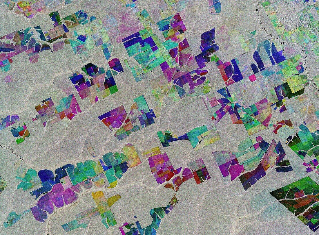
| Deforestation in Brazil, satellite radar image. This image combines three separate radar images taken about two years apart to show change in crops and land cover over time, with the square areas showing fields of crops replacing forest trees as part of a process of deforestation. The first image, from 2 May 2015, is in blue; the second, from 16 March 2017, shows changes in green; while the third from 18 March 2019 is in red; areas in grey depict little or no change between 2015 and 2019. This area is in the Brazilian state of Mato Grosso deep in the Amazon interior. Image data obtained by the Copernicus Sentinel-1 satellites. | |
| Lizenzart: | Lizenzpflichtig |
| Credit: | Science Photo Library / Copernicus Sentinel data (2015-19 / EUROPEAN SPACE AGENCY |
| Bildgröße: | 8572 px × 6335 px |
| Modell-Rechte: | nicht erforderlich |
| Eigentums-Rechte: | nicht erforderlich |
| Restrictions: |
|
Preise für dieses Bild ab 15 €
Universitäten & Organisationen
(Informationsmaterial Digital, Informationsmaterial Print, Lehrmaterial Digital etc.)
ab 15 €
Redaktionell
(Bücher, Bücher: Sach- und Fachliteratur, Digitale Medien (redaktionell) etc.)
ab 30 €
Werbung
(Anzeigen, Aussenwerbung, Digitale Medien, Fernsehwerbung, Karten, Werbemittel, Zeitschriften etc.)
ab 55 €
Handelsprodukte
(bedruckte Textilie, Kalender, Postkarte, Grußkarte, Verpackung etc.)
ab 75 €
Pauschalpreise
Rechtepakete für die unbeschränkte Bildnutzung in Print oder Online
ab 495 €
Keywords
- 2015,
- 2017,
- 2019,
- 21. Jahrhundert,
- Abholzung,
- amazonisch,
- Bauernhof,
- Bodennutzung,
- Brasilianer,
- Brasilien,
- copernicus,
- Erdbeobachtung,
- Feld,
- Felder,
- Feldfrüchte,
- geografisch,
- Geographie,
- Landwirtschaft,
- landwirtschaftlich,
- Lateinamerika,
- Mato Grosso,
- Niemand,
- Regenwald,
- Reihenfolge,
- Satellit,
- Satellitenbild,
- Sentinel-1,
- Serie,
- Südamerika,
- Südamerikanisch,
- Wald,
- Weltall,
- Zusammengesetzt